LandGlide: GPS Property Finder
- 2.46K
- 4.3
- Installs
- 1.00M
- Price
- Free

Screenshots
Analysis by Reviewed
When I need to make sense of a stretch of land, the first challenge is often knowing where one property ends and another begins. LandGlide is built for that kind of curiosity: it uses a map and your location to help you look up parcels, rather than asking you to start with a real estate listing. I find that focus useful for quick research, though it helps to treat a map-based lookup as a starting point, not a substitute for formal property records or on-the-ground confirmation.
What to expect when opening the map
LandGlide is a free Maps & Navigation app from Real Estate Portal USA, available for Android and iOS. It has a 4.3 average from around 8,600 ratings, and has been installed over a million times. Those figures suggest a well-used tool, but they don’t tell me how quickly it will load on every phone or in every location. In practice, I’d expect the experience to depend on GPS reception, the connection available, and how much detail I’m asking the map to show.
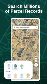
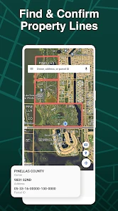
The basic workflow is appealingly direct: use your position to explore nearby parcels, or search by an owner, street address, or parcel identifier when you already have a lead. That flexibility matters when a road sign gives you an address but a rural property has no obvious number. If a result is slow to appear, I’d first check whether the phone has a clear location fix and try searching by another known detail rather than assuming the parcel itself is missing.
When a property search gets more demanding
Browsing a single block is a different job from comparing several possible properties across town. For a heavier session, I’d keep a short list of addresses or parcel details and check them one at a time, saving candidates for later instead of repeatedly retracing the same area. That is a practical way to keep research organized, especially if I’m looking while walking or riding with someone else driving. I would not use the app while driving; stopping somewhere safe keeps attention on the road and makes map details easier to inspect.
For example, imagine I’m considering a house and want to understand the shape of the neighboring lots before arranging a visit. I can search the address, inspect the mapped parcel, then compare nearby properties and save the ones I may want to revisit. This helps me prepare better questions for an agent or a local records office. It doesn’t establish a legal boundary on the ground, so I wouldn’t use a screen outline to decide where to build, fence, or settle a dispute.
Reliability, limitations, and who it suits
The app’s appeal is its narrow purpose: parcel discovery without the broader clutter of a conventional street-navigation app. A general map is usually better for turn-by-turn directions, traffic, or finding a shop; a real estate marketplace is better for browsing homes for sale and comparing listing details. I’d reach for LandGlide when the question is specifically “which parcel is this?” rather than “how do I get there?” or “what homes are on the market?”
That distinction also sets expectations for reliability. GPS can place a phone near a parcel, but location precision and mapped lines are not the same as a survey. I’d cross-check anything consequential with official local records or a qualified professional. The app is most useful to curious neighbors, prospective buyers doing early homework, and property professionals who want a quick field reference; it is a poor fit for anyone who needs certified boundary evidence or a full navigation system.
More From Our News Desk

Clash of Clans Is Won Between the Battles

Android Auto Makes the Case for Quieter Car Software

MobiOffice: Transforming Mobile Productivity with Seamless Integration

EA SPORTS FC™ Mobile Soccer: Redefining Mobile Sports Gaming

How Microsoft OneDrive Became a Mobile Productivity Giant

How Google Translate Breaks Language Barriers Effortlessly
LandGlide is rated for Everyone, and its current version is 5.4.1, with Android 8.0 or later required. That minimum makes it accessible to many older Android devices, though an older handset may still feel less responsive than a newer one, particularly when location services or map rendering are under strain. I’d also keep battery in mind during a long outdoor session: GPS use can be demanding on a phone, so bringing a charged device is sensible. The app’s listed in-app purchases range from $9.99 to $99.99 per item, so I’d check the available terms in the app before relying on continued access; “free” does not mean every use is cost-free.
A practical routine for a first visit
For a first look at a property, I’d prepare the address or parcel detail before leaving, then use the map to orient myself once I’m safely parked. That small bit of preparation makes the app more useful than simply opening it and wandering around: I have a known result to compare against the nearby parcels, and I can note what I still need to verify later. If I’m visiting several places, I’d keep the list short enough to review carefully rather than racing through a long sequence of pins and outlines.
This approach is especially helpful when a home sits on a large lot or the road frontage is not obvious. I can use the parcel view to frame questions—whether a neighboring strip appears separate, for example—without assuming the display settles ownership or access rights. The useful outcome is often a better conversation with a local professional, not a final answer from the phone.
Who will get the most from it
I’d recommend trying it to people who regularly notice unfamiliar land, are evaluating a potential purchase, or need a quick parcel-oriented reference while working in the field. It can also suit someone who wants to investigate a property before calling an agent, because searching by an owner or parcel identifier offers a route beyond ordinary listing pages. The value is greatest when the user already understands that parcel information is one piece of research, not a complete report on a property.
On the other hand, I’d skip it if I only need directions, public transit options, traffic conditions, or a polished overview of homes currently for sale. It is also not the right tool for proving a boundary, settling a neighbor disagreement, or deciding where construction can legally go. In those cases, a navigation app, property marketplace, county records, or a licensed surveyor is a better match for the actual question.
Ever wondered who owns that mysterious piece of land you pass by every day? Or maybe you're a real estate enthusiast always on the hunt for new opportunities? Well, let me introduce you to LandGlide, the GPS property finder that's about to become your new best friend. As someone who's always been curious about the properties around me, I decided to give this app a whirl, and let me just say, it did not disappoint!
Getting Started with LandGlide
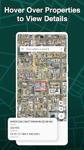
First off, downloading the app is a breeze. Available for both Android and iOS, you can find it easily on the Google Play Store or Apple App Store. Once installed, the app greets you with a sleek and intuitive interface. With a simple tap, LandGlide displays property boundaries and owner information right at your fingertips. No more speculating about who owns what; this app spills the beans in seconds!
The Nitty-Gritty Features
So, what makes LandGlide stand out from the crowd? For starters, its coverage is massive, offering detailed property info across the United States. Whether you're in bustling New York or the serene landscapes of Montana, LandGlide has got you covered.
The app’s GPS integration is pretty spot-on, allowing you to wander around neighborhoods while simultaneously learning about each property you encounter. It’s like having a real estate agent in your pocket, minus the commission fees! The app allows you to search by owner name, address, or parcel number—so you’ve got plenty of ways to track down the info you need.
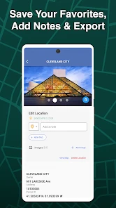
Another feature that had me hooked was the ability to save favorite properties. Whether you’re a prospective buyer, real estate agent, or just a curious cat, saving properties for future reference is an invaluable tool. Plus, the data is updated frequently, ensuring that you’re always in the loop with the latest property details.
My Experience Using LandGlide
As someone who’s not exactly a tech wizard, I found LandGlide to be incredibly user-friendly. The app is smooth, responsive, and doesn’t bombard you with unnecessary ads—a major win in my book! Navigating through different properties was seamless, and I felt like a pro property scout in no time.
However, it’s worth noting that while the app offers a free trial, continued use requires a subscription. That said, for the depth of information and ease of use it offers, I found it to be worth every penny.
Final Thoughts
In a nutshell, if you’re in the market for a robust property finder, LandGlide is definitely worth checking out. Whether you’re buying, selling, or just plain curious, this app opens up a world of property possibilities. It’s like having a magic lens that reveals the secrets of every plot of land you encounter.
So, next time you’re out and about, whip out your phone, fire up LandGlide, and explore the land ownership landscape like never before. You might just uncover your next big real estate opportunity!
Making field research more useful
One practical habit is to begin with a known address or parcel number before relying on the GPS view. That gives me a reference point if I’m standing near a property line, where a small location drift could make neighboring parcels look like the one I want. When I’m exploring without an address, I’d compare several nearby parcels and use visible roads and landmarks to orient myself instead of treating the phone’s dot as an exact boundary marker.
Saving a property is most valuable when it supports a next step. I might keep a handful of parcels to compare after getting home, then use the saved list as a prompt to check public records, ask an agent a more specific question, or plan a visit. That workflow is better than trying to make a purchase decision from a roadside glance. It also helps separate casual curiosity from a serious lead, so I’m not relying on memory after looking at many lots.
Choosing the right tool for the job
For someone inspecting land, a standard map app can show roads and help with routing, but it is not designed around parcel lookup. Property marketplaces, meanwhile, focus on homes and listings, which may not answer questions about an undeveloped lot or the owner associated with a parcel. LandGlide fills that narrower gap. I’d use it alongside those tools rather than expecting it to replace them: route with a navigation app, browse homes on a listing service, and use parcel search to guide early research.
It is also worth thinking about the setting before heading out. In a dense neighborhood, I can compare parcels while using nearby streets as context. On a large rural property, the same screen may be harder to interpret because landmarks are sparse and GPS positioning can be less helpful for distinguishing adjacent land. If I need certainty in that situation, I’d consult authoritative records or a surveyor rather than trying to solve it by zooming in further.
Access and a sensible performance check
A common question is whether I can count on the free download for ongoing research. The app costs nothing to install, but in-app purchases are offered, so I’d review the current access options before planning a long project around it. That matters most for buyers or professionals who expect to revisit many parcels over time; a brief exploratory outing and sustained research are different needs. I’d make sure the access level suits my intended use before depending on it for repeated work.
If the map seems sluggish, I’d take a simple recovery approach: pause, confirm that location is available, and retry a search using an address or parcel detail. If the phone is struggling after a long outing, closing other demanding tasks and letting it cool can help with general device responsiveness, though it cannot fix weak reception or incorrect source information. I would avoid interpreting a delayed display as proof that a property record is absent. Checking the same parcel through a second search method is a more useful test.
For a casual user, that modest troubleshooting is usually enough to keep the app useful without turning a walk into a technical exercise. For regular fieldwork, I’d also plan around battery life and keep a note of the addresses I want to investigate, so I’m not spending time repeatedly searching from scratch. The app is a focused companion, not a complete property-research office in your pocket, and that distinction is a strength when expectations are realistic.
My overall take
LandGlide works best when I want a quick, map-centered clue about a parcel and know that important decisions need stronger evidence. It gives curious explorers and early-stage buyers a convenient way to turn a location into a more informed question. I’d skip it if my main need were driving directions, listing comparisons, or legally dependable boundary placement. Used for discovery, with a sensible cross-check for anything important, it earns a place in my property-research toolkit.
LandGlide: GPS Property Finder Frequently Asked Questions
Can LandGlide help me find a parcel if I don’t know its address?
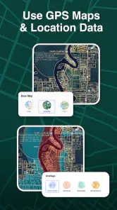
Yes. LandGlide lets you search by property owner or parcel as well as by address, and you can also use GPS maps to view parcel data around your current location. Those options can make it easier to explore a place when you have only an owner’s name or parcel information to start with. The app is focused on locating parcels and viewing property information.
What is LandGlide and how does it work?
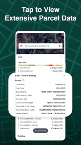
LandGlide is a GPS property app designed to help users easily locate and access property information. It utilizes your device's GPS to provide detailed property boundaries and ownership details. Users can search for properties by address or view their own location to see property lines in real-time. With a subscription, you can also access additional details such as tax data and property owner contact information.
Is LandGlide free to use?
LandGlide offers a free trial period during which users can explore its features and capabilities. After the trial, a subscription is required to continue accessing the full range of features, including detailed property data and offline access. Pricing varies based on the subscription plan chosen, so it's advisable to check the latest pricing details within the app or on the official website. The app is free to download, with in-app purchases available.
What devices are compatible with LandGlide?
LandGlide is compatible with both Android and iOS devices. It requires a device with GPS capabilities to accurately display property boundaries and location data. The app is optimized for smartphones and tablets, ensuring a smooth user experience across different screen sizes and resolutions. Ensure your device's operating system is updated to the latest version for optimal performance.
How accurate is the property data in LandGlide?
LandGlide sources its property data from public records and updates it regularly to maintain accuracy. While the app strives to provide the most current and precise information, it's important to note that discrepancies may occur due to changes in public records or mapping errors. Users are encouraged to verify critical property details with local authorities if absolute accuracy is required.
Pros
- Accurate GPS property boundaries.
- Fast loading of property details.
- Offline access available.
- User-friendly interface.
- Detailed property information.
Cons
- Requires subscription for full access.
- Limited free features.
- Occasional GPS inaccuracies.
- High battery consumption.
- No option for route planning.
- Category
- Maps & Navigation
- Version
- 5.4.1











