Land Nav Assistant
- 113.00
- 4.1
- Installs
- 50.00K
- Price
- $2.99
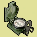
Screenshots
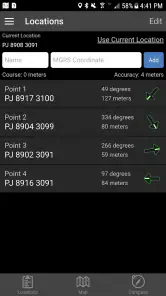
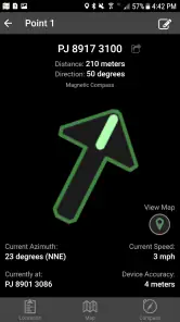
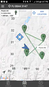
Analysis by Reviewed
I reach for land-navigation tools when I need more than a familiar street map: a clear way to work with coordinates, bearings, and locations away from ordinary roads. Land Nav Assistant is aimed at that kind of trip, with MGRS and latitude/longitude navigation for military and outdoor use. I’d consider it a specialist companion rather than a replacement for every map app on my phone.
Where a connection changes the plan
Navigation apps can feel dependable in town and behave differently once a route leaves the network. I would plan a trip with Land Nav Assistant before setting off: decide which coordinate format the group will use, note important destinations, and check that everyone understands how to read the location information. That preparation matters because a navigation tool is most useful when you already know what you need from it, not when you are trying to learn its controls under pressure.
For a trailhead approach, a field exercise, or a search for a marked campsite, MGRS may fit the task better than sharing a pin through a mainstream map. If friends use latitude and longitude instead, agreeing on that format in advance can prevent the small but consequential confusion of exchanging coordinates in different systems. I would still keep a paper map or another suitable backup for serious trips; no phone should be the only part of a safety plan.
A practical fit for outdoor routines
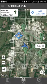
Here is an everyday example: I arrive at a large park with a group, save the meeting point, then split up to follow separate routes. A coordinate-focused tool can make it easier to describe a precise location than “near the bend after the trees,” especially if the group is comfortable with the same coordinate system. On a solo walk, recording a starting point can also help me orient myself when I want to retrace my route.
That precision comes with a learning curve. Someone who only wants turn-by-turn directions to a café will probably have an easier time with a conventional map app, while a hiker who shares MGRS references or works from coordinates has a clearer reason to choose this one. I would practise entering and checking a destination somewhere familiar first, and avoid treating a displayed bearing as a substitute for paying attention to terrain and changing conditions.
Using Land Nav Assistant in the Field
First things first, let's talk about setting up the Land Nav Assistant. I found the installation process to be a breeze. Once installed, the app opens up with a clean and intuitive interface. It's designed to be user-friendly, which is fantastic because, let's face it, when you're out in the middle of nowhere, the last thing you want is to be fiddling with a complicated app.
Features That Stand Out
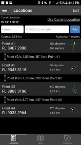
The app is packed with features that are incredibly useful for navigation. One of the standout features for me is the ability to create and save waypoints. This means you can mark specific locations and easily navigate back to them whenever you need to. It's like having a digital breadcrumb trail!
More From Our News Desk

Clash of Clans Is Won Between the Battles

Android Auto Makes the Case for Quieter Car Software

MobiOffice: Transforming Mobile Productivity with Seamless Integration

EA SPORTS FC™ Mobile Soccer: Redefining Mobile Sports Gaming

How Microsoft OneDrive Became a Mobile Productivity Giant

How Google Translate Breaks Language Barriers Effortlessly
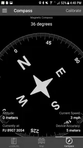
Another feature that I love is the compass. It's accurate and reliable, which is crucial when you're out in the wild. Plus, it doesn't drain your battery as much as some other navigation apps I've used. That's a huge plus in my book!
Preparing for gaps and interruptions
I would not assume every useful part of a navigation app behaves the same way when a connection drops. Before relying on it beyond coverage, I would test the tasks I plan to use, check any necessary map material while I still have service, and keep a written note of key coordinates. This is a sensible habit even for experienced users: a saved waypoint is only helpful if I know how to find and interpret it when conditions are distracting.
Battery planning deserves the same attention. A compass and GPS use can compete with other phone demands, so I would begin with a charged device, keep screen use purposeful, and carry a backup power option on a longer outing. If the app appears to lag or gives an unexpected reading, I would pause, check my position again after a moment, and compare it with terrain or a second navigation method rather than walking on a guess.
Who benefits—and who may prefer another map
Gammon Applications has kept this focused on a particular kind of navigation. It is a plausible choice for outdoor enthusiasts, people who exchange MGRS coordinates, and users who want a dedicated tool alongside their usual maps. It is less compelling for a driver or casual city visitor who mainly needs live traffic, business listings, or spoken directions; those are better served by familiar road-navigation apps.
The app costs $2.99, has an Everyone age rating, and runs on Android 5.1 or later. Its current version is 2024050107. I see those details as useful context, but the bigger decision is whether coordinate-based navigation matches the way you actually travel. The store shows a 4.1 average from 338 ratings, with 50K+ installs and 113 written reviews: enough to suggest an established niche audience, while still leaving room for individual preferences and device differences.
Choosing a sensible field workflow
For a group outing, I would agree on a destination format before anyone starts walking, then have each person verify the same reference on their own screen or paper notes. That simple cross-check is more useful than assuming everyone interprets a coordinate the same way. It also gives the group a clear fallback if one phone becomes hard to read or a person needs to explain their location by voice.
Waypoints work best when they represent decisions, not every passing landmark. I would save the car, a junction, and a meeting point rather than cluttering the list with places that will not matter later. This keeps the return route easier to reason through and reduces the chance that, tired or in poor light, I select a marker whose meaning I have forgotten.
There is also a useful distinction between navigation precision and route knowledge. A coordinate can help the group converge on a point, but it does not tell me whether the ground between us is steep, blocked, or unsafe. I would use the app to communicate position and direction while relying on a map, local knowledge, and observation to judge the route itself.
When the usual map app is the better tool
Compared with a general-purpose map, this app’s appeal is the coordinate-oriented task rather than a broad set of city conveniences. Mainstream navigation is usually a better fit when I need addresses, traffic-aware driving, nearby shops, or spoken turn prompts. Land Nav Assistant makes more sense when a location is described in MGRS or latitude and longitude and that vocabulary is already part of the trip.
That difference matters for mixed-experience groups. A coordinate-focused tool can make a precise handoff clearer for trained users, but it may slow down companions who have never entered or interpreted coordinates. In that situation, I would not insist that every person learn the app on the trail; I would establish one shared reference method beforehand and use a familiar map as a second way to understand the surroundings.
I would also treat a specialist app as one part of a kit, not as proof that a route is manageable. If the outing depends on detailed terrain context, route guidance, or reliable communication among people using different tools, another map may be the more important purchase. The best choice depends on what information the group needs to act on, not simply which app has the most navigation features.
Why I Love It
Now, let me tell you why I think this app is a must-have for anyone who loves hiking, camping, or just exploring new places. The Land Nav Assistant is not just about finding your way; it's about enhancing your whole outdoor experience. Whether you're a seasoned hiker or a weekend warrior, this app offers a level of security and peace of mind that allows you to focus on enjoying your adventure.
One of the things that really impressed me is how the app integrates with offline maps. You don't always have cell service out in the wilderness, and having offline maps is a lifesaver. It's like having your own personal guide, even in the most remote areas.
Keeping information useful and lean
Coordinate navigation is most helpful when the information is tidy. I would label saved points in a way that makes sense later—such as “north trail junction” or “car park”—rather than leaving several vague markers to decode at the end of a long day. Before sharing a location, I would also read the coordinates back to the other person so that a mistyped digit or mismatched format does not send them to the wrong place.
If you are mindful of mobile data, do any map-related preparation before leaving dependable coverage and avoid repeatedly reopening large map views unless needed. That is not a promise that every function works without a network; it is simply a practical way to reduce surprises. For privacy-conscious users, the same restrained workflow helps: share only the location needed for the task, and avoid treating a phone full of saved points as a permanent record of every outing.
Cost, compatibility, and the right expectations
At $2.99, the decision is less about replacing every navigation tool and more about whether coordinate work is a regular part of your outings. If you will use MGRS or latitude/longitude repeatedly, paying for a dedicated app may be worthwhile. If you only take an occasional walk on marked paths, your existing map app and a basic paper backup may be enough.
Its Everyone rating makes the age classification straightforward, but ease of use still depends on the person holding the phone. A younger or first-time navigator may need someone to explain coordinate formats and bearings before heading out. I would take a few minutes at home to practise, especially if the group includes people who normally navigate by street names or map pins.
The listed Android requirement is version 5.1 or later, and the current release is 2024050107. Those details help with basic compatibility checks, but I would still test the app on the actual phone intended for a trip. Screen size, battery condition, and how comfortably I can read the display outdoors can affect the experience just as much as the software itself.
Final Thoughts
So, there you have it, folks! The Land Nav Assistant is a fantastic tool for anyone who loves the outdoors. It's easy to use, packed with features, and most importantly, it works when you need it the most. If you're planning your next adventure, I highly recommend giving this app a try. Happy exploring!
My recommendation comes with one qualification: I would not buy it expecting the all-purpose convenience of a mainstream navigation app, nor would I head into remote terrain without testing my workflow first. For someone who already uses MGRS or wants a focused coordinate companion, its approach can make field navigation more deliberate and communication clearer. For everyone else, the better choice may be the map app that already fits their everyday routes.
Land Nav Assistant Frequently Asked Questions
What coordinate formats does Land Nav Assistant support?
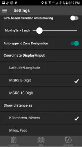
Land Nav Assistant is geared toward GPS navigation using MGRS and latitude/longitude coordinates, making it relevant to outdoor users and people familiar with military-style grid references. Before relying on it in the field, make sure you know which format your route or destination uses and that you can read the coordinates correctly. Familiarity with the chosen system helps avoid confusion when entering or sharing locations.
What is Land Nav Assistant’s price and who develops it?
Land Nav Assistant is a paid navigation app from Gammon Applications, priced at $2.99. Its focus is GPS MGRS and latitude/longitude navigation for military and outdoor enthusiasts. It has a 4.1 average rating, based on 338 ratings, and is rated Everyone. Check the price shown in your device’s app store before purchasing, since the amount displayed there is the one that applies to your transaction.
What is the primary purpose of Land Nav Assistant?
Land Nav Assistant is designed to help individuals improve their land navigation skills by providing tools and resources commonly used in orienteering, hiking, and military training. The app includes features like waypoint plotting, compass integration, and distance measurement to assist users in navigating unfamiliar terrains effectively.
Is Land Nav Assistant suitable for beginners in navigation?
Absolutely, Land Nav Assistant caters to both beginners and experienced navigators. The app includes tutorials and a user-friendly interface that make it easy for novices to learn the basics of land navigation. Meanwhile, more advanced features like detailed waypoint management and compass calibration cater to seasoned users looking for precise navigation tools.
Does Land Nav Assistant require an internet connection to function?
No, one of the key advantages of Land Nav Assistant is its ability to function offline. Users can download maps and set waypoints before heading out, ensuring that they have access to critical navigation tools even in remote areas without internet connectivity. This feature makes it highly reliable for outdoor adventures.
Pros
- Easy to use interface for beginners.
- Accurate real-time GPS tracking.
- Supports offline map downloads.
- Custom waypoint creation feature.
- Detailed compass and navigation tools.
Cons
- Battery consumption is high.
- Limited map customization options.
- Occasional app freezes on some devices.
- Requires GPS signal for full functionality.
- No integration with other navigation apps.
- Category
- Maps & Navigation
- Version
- 2024050107











