iFly EFB
- 366.00
- 4.9
- Installs
- 50.00K
- Price
- Free

Screenshots
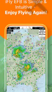
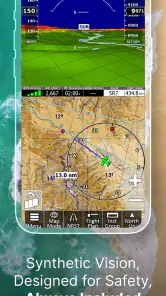
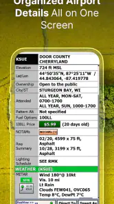
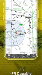
Analysis by Reviewed
When I review a flight app, I do not begin with the feature list. I begin with a more practical question: can I understand what I am seeing quickly, keep my attention on the flight, and operate the app without creating extra workload? That is the standard I applied to iFly EFB, an aviation app from Adventure Pilot, LLC that is designed for both visual and instrument flight planning. It is free to install, rated for Everyone, and has built a strong reputation with a 4.9 average from around 700 ratings and more than 50 thousand installs.
My overall impression is that this is a serious electronic flight bag rather than a casual map viewer. It is aimed at pilots who want aviation-specific information in one place, especially those who move between VFR and IFR work. The free entry point makes it easy to explore, although optional in-app purchases range from $0.99 to $179.99 per item, so the eventual cost depends heavily on how much of the system you need.
How iFly EFB handles readability, navigation, and different flying contexts
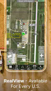
The first thing I noticed is that the app is built around the way pilots actually think about a flight: position, route, airspace, airports, and changing conditions. That focus makes it more useful than a normal road-navigation app, because the information is aviation-specific instead of being squeezed into a general-purpose map. A pilot preparing a local daytime flight can approach it differently from someone organizing an instrument route, yet both use the same central environment.
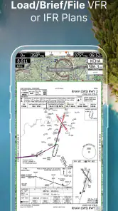
Readability matters enormously in an EFB. A chart can contain far more information than an ordinary map, and the danger is not simply that text becomes small. The real problem is visual competition: airport data, airspace boundaries, route details, terrain information, and navigation references can all demand attention at once. In my experience, iFly EFB works best when I treat the screen as a planning workspace and deliberately adjust the view before I need it. Zooming and positioning the chart ahead of time is much less stressful than trying to solve the display while busy.
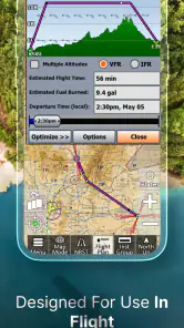
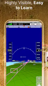
I also like the distinction between planning and in-flight use. During planning, I can afford to inspect details, compare route choices, and pause over an airport or area of airspace. In the cockpit, I need the map to answer narrow questions quickly: where am I, what is ahead, and how does the current route relate to the surrounding aviation environment? That change of purpose is easy to overlook, but it is central to using any EFB safely.
For pilots who find dense screens tiring, a useful habit is to build a short preflight routine around the app. I would set the chart view, confirm the route, check the relevant airports and airspace, and then avoid unnecessary exploration once the flight begins. This is not a special accessibility mode; it is simply a way to reduce visual and cognitive clutter. It also helps pilots who are new to electronic charts because it turns a large information space into a repeatable sequence.
The interface feels more appropriate for someone willing to learn aviation software than for a first-time smartphone user who expects instant simplicity. The app’s strength is depth, and depth always brings a learning curve. I would not judge it by the standard of a basic navigation app, because the extra information is the reason to choose it. Still, a new pilot should spend time with it on the ground rather than discovering important controls during a busy phase of flight.
More From Our News Desk

Clash of Clans Is Won Between the Battles

Android Auto Makes the Case for Quieter Car Software

MobiOffice: Transforming Mobile Productivity with Seamless Integration

EA SPORTS FC™ Mobile Soccer: Redefining Mobile Sports Gaming

How Microsoft OneDrive Became a Mobile Productivity Giant

How Google Translate Breaks Language Barriers Effortlessly
Why the VFR and IFR focus changes the experience
One of the most useful aspects of iFly EFB is its relevance to different kinds of flying. VFR pilots need a clear relationship between their position, landmarks, airports, and controlled or restricted areas. IFR pilots need a more structured view of routes and procedures, with less room for casual interpretation. An app that supports both contexts can follow a pilot through different stages of training and experience instead of becoming useful only for one type of flying.
That flexibility does not mean every pilot will find every view equally comfortable. A recreational pilot who only wants a simple moving map may feel that the aviation detail is excessive. Conversely, a pilot who expects a complete replacement for every paper reference, aircraft instrument, or approved operational source should be cautious. I see this app as a powerful planning and situational-awareness tool, not as permission to ignore aircraft equipment, current procedures, or normal cockpit discipline.
A realistic example is a weekend flight to an unfamiliar airport. Before leaving, I would use the app to study the route, identify nearby airports, examine the surrounding airspace, and make sure the chart presentation is comfortable on the device I plan to carry. In the air, the benefit is not that the app makes decisions for me. The benefit is that it gives me a more coherent picture of the route and its surroundings, provided I have prepared it properly and continue to cross-check what matters.
Motor and sensory considerations in actual use
Touchscreen operation introduces a physical issue that is easy to miss in a review: tapping, dragging, and zooming are not equally easy for everyone. A pilot with reduced fine motor control may find small chart targets or tightly packed controls demanding, especially in turbulence. Someone wearing gloves may also have a different experience from someone using a bare fingertip. I would therefore test the app on the exact device and mounting position intended for flight, rather than assuming that a comfortable desk setup will remain comfortable in the cockpit.
The safest workflow is to do as much interaction as possible before takeoff. Route preparation, chart positioning, and familiarization should happen while stationary. In flight, I would favor brief, deliberate actions and avoid repeated searching through menus. This is useful for anyone, but especially for pilots who experience hand fatigue, tremor, limited reach, or slower touch accuracy.
Visual sensitivity is another consideration. Aviation charts are inherently busy, and prolonged attention to a bright screen can be tiring. I would adjust device brightness to the cockpit environment, avoid leaving the display brighter than necessary, and keep a clear division between information that is essential now and information that can wait. A pilot who is sensitive to glare or high-contrast detail may need to experiment with the device angle and surrounding lighting as much as with the app itself.
For pilots with hearing differences, the app’s visual presentation can be valuable because it does not depend on hearing a spoken instruction to understand the route picture. At the same time, it does not replace radio communication, visual lookout, or other cockpit cues. That distinction is important: a strong visual tool can support situational awareness, but it cannot remove the need to receive and interpret information from the aircraft environment.
Pilots who process information more slowly may benefit from using the app in layers. I would first confirm the route and current position, then inspect airspace, then review airport details, rather than trying to absorb the entire chart at once. This staged method also works for people who become overloaded by dense displays. The app provides the information, but the pilot still has to create a personal method for filtering it.
Situational access from preparation to cockpit workload
Accessibility in aviation is not only about whether a button can be pressed. It is also about whether the right information can be found at the right moment without breaking concentration. iFly EFB is most helpful when it reduces the need to carry several disconnected references in your head. A route, its surrounding airspace, and nearby airports can be considered together instead of as unrelated pieces.
That is particularly useful when plans change. Imagine departing for a short flight and deciding to divert because of weather, traffic, or a passenger need. A general map app may show roads and locations, but it is not built around aviation alternatives. An EFB gives the diversion question a more relevant context: which airports are nearby, how does the new destination relate to the route, and what surrounding information needs attention? I would still verify every operational detail through the appropriate current source, but the app can make the first stage of the decision more organized.
It is also useful for training. A student pilot can review the same route before and after a lesson, compare what was expected with what was encountered, and build familiarity with the visual relationship between airports and airspace. An instructor or experienced pilot can use that preparation to discuss workload rather than spending the entire briefing explaining where basic map elements are located.
Another practical strength is continuity between different flight purposes. A pilot may use VFR planning for local trips and later need IFR-oriented preparation. Keeping one familiar EFB can reduce the friction of learning an entirely different application. That does not guarantee that every advanced workflow will suit every pilot, but it does make the transition less disruptive than switching between unrelated tools.
For users with limited access to physical paperwork or difficulty managing several printed charts, a digital EFB may be easier to organize. The advantage is not automatic, however. A tablet or phone still needs to be charged, mounted safely, and positioned where it can be viewed without unsafe head movement. Digital convenience becomes a liability if the device placement forces awkward reaching or blocks other instruments.
Where the app still creates barriers
The biggest barrier is complexity. iFly EFB is not the kind of app I would recommend to someone who only wants a quick visual reference with no aviation learning curve. The combination of VFR and IFR capability means there is more to understand, and a pilot who skips familiarization may feel lost precisely when the workload rises. The free installation is helpful for trying it, but the optional purchases can make the full experience less straightforward to budget for.
That pricing structure deserves attention before relying on the app for a particular operation. I would install it, explore the available functions, and identify which paid items match my actual flying before building a regular workflow around it. A pilot who only flies occasionally may not need the same level of coverage or capability as someone who flies frequently. The right choice depends on use, not simply on the fact that the app is free to download.
Device dependence is another limitation. A small phone can be convenient, but a dense aviation chart may be less comfortable to inspect on it than on a larger screen. A larger device improves readability for many people but may be harder to mount or reach. Pilots with visual, motor, or attention-related needs should make this decision based on cockpit ergonomics, not just screen specifications.
I would also avoid treating the app as a single-source answer. Aviation information changes, and safe flight planning requires current, appropriate references and sound pilot judgment. An EFB can organize information beautifully and still be used incorrectly if the pilot assumes that a digital display removes the need for verification. This is not a flaw unique to iFly EFB, but it is an important boundary around its usefulness.
There is also a human-factors limitation: a screen can encourage overconfidence. Because the map looks precise, it may feel more authoritative than it really is in a changing situation. I find the app most valuable when it supports a mental model I already understand, rather than when I use it as a substitute for understanding the route. Pilots who prefer paper backups or independent references should keep those habits where appropriate.
Who should use it, and who should choose something simpler
I would recommend iFly EFB to pilots who want an aviation-specific planning environment, expect to fly in both VFR and IFR contexts, and are willing to spend time learning the workflow. It is also a good fit for students who want to develop disciplined electronic-chart habits early, provided they receive proper instruction and do not confuse the app with a complete training system.
I would be more hesitant to recommend it to a casual user who wants only a simple moving map, or to someone who strongly dislikes dense interfaces. A simpler navigation product may be easier for occasional reference, especially when the user does not need aviation-specific route and airspace context. Likewise, pilots with significant touch-control difficulties should test the app in their real cockpit setup before committing to it as a primary tool.
The app’s audience is reflected in its long presence on mobile platforms: it was released on January 20, 2014, and has accumulated around 366 written reviews alongside its ratings. Those figures do not tell me whether it will suit every pilot, but they do suggest that it has remained relevant to a substantial group of aviation users rather than being a short-lived experiment.
What I appreciate most is the balance between broad capability and practical preparation. The app can serve a local VFR pilot today and remain relevant if that pilot later develops IFR needs. The trade-off is that the user must take responsibility for configuring the experience, understanding the information, and deciding when a simpler tool would create less workload.
My inclusive verdict after using it as a pilot’s planning companion
My final view is positive, with an important qualification: iFly EFB is inclusive mainly when the pilot adapts the workflow to personal needs and flying conditions. Its aviation focus can reduce the confusion of switching between generic maps and specialized references. Its support for both VFR and IFR contexts makes it more versatile than a basic navigation app, and its free installation gives pilots a practical way to investigate the experience before spending money.
It is not automatically accessible for every person. Dense charts, touch interaction, device placement, and cockpit workload can still create real barriers. I would prepare routes on the ground, use a screen size and mounting position that support comfortable viewing, limit in-flight interaction, and build a backup plan that does not depend on one device. Those steps are especially important for pilots with visual, motor, sensory, or processing differences.
Adventure Pilot, LLC has created an EFB that feels aimed at serious aviation use rather than casual map browsing. The app is free, carries an Everyone age rating, and its optional purchases offer a range of ways to expand what it can do, from $0.99 items up to $179.99 items. I would not buy anything until I knew exactly which part of my flying it would improve.
My recommendation is to try it on the ground, in the device you will actually use, and judge it by workload rather than by feature count. If you want a capable aviation charting companion and are prepared to learn its structure, it can become a dependable part of your planning routine. If your priority is the simplest possible display, or if touch interaction is difficult in your setup, another option may be more comfortable. For pilots who value one aviation-focused environment across VFR and IFR preparation, however, this is a thoughtful and worthwhile app to consider.
iFly EFB Frequently Asked Questions
Is iFly EFB available for both Android and iOS?
iFly EFB is a mobile electronic flight bag app in the Maps & Navigation category. Before downloading, check the app store on your device to confirm compatibility and review the current system requirements. Since cockpit use depends on a reliable device, it is sensible to make sure the app runs properly on your intended phone or tablet and that you can access the charts and tools you need.
Who develops iFly EFB, and what is its general reputation?
iFly EFB is developed by Adventure Pilot, LLC. It has an average rating of 4.9 from around 700 ratings, with more than 300 written reviews, reflecting strong user interest. Ratings are only one part of choosing an aviation app, so pilots should also check whether its coverage, features, and device compatibility suit their own aircraft and operations before depending on it in the cockpit.
What is iFly EFB, and who is it designed for?
iFly EFB is an electronic flight bag application designed primarily for pilots who need digital navigation charts, airport information, flight planning tools, and in-flight situational awareness. It is especially associated with general aviation and pilots using compatible iFly GPS hardware or services. Before downloading, check whether its supported regions, chart coverage, device requirements, and subscription options match the type of flying you do.
Does iFly EFB require a subscription or additional purchases?
The app is free to install, but in-app purchases range from $0.99 to $179.99 per item, and many important functions can depend on an active subscription, purchased chart coverage, or an iFly-related service plan. Costs and included features can vary by country, platform, and product package. Review the current pricing, renewal terms, chart regions, and any hardware requirements in the official app listing before relying on it for flight operations.
Can iFly EFB be used without an internet connection?
iFly EFB can support offline use when the required charts, airport data, terrain information, and other resources have been downloaded in advance. However, offline availability depends on the selected coverage and the version of the application. Internet access is still useful for updates, weather information, account synchronization, and database changes. Pilots should prepare all materials before departure and never assume live services will work in the air.
Pros
- Clear aviation charts and airport information in one place.
- Useful flight-planning tools for pilots and flight crews.
- Supports offline access to downloaded charts and documents.
- Regular data updates help keep navigation information current.
- Organized interface makes frequently used resources easy to find.
Cons
- Many advanced features may require a paid subscription.
- Initial chart and document downloads can use considerable storage.
- The app may feel complex for student or occasional pilots.
- Offline content must be downloaded before losing internet access.
- Performance can depend on device quality and GPS availability.
- Category
- Maps & Navigation
- Version
- Varies with device











