GPX Viewer PRO
- 213.00
- 4.6
- Installs
- 100.00K
- Price
- $8.99

Screenshots
Analysis by Reviewed
I reach for a GPX viewer when a route already exists and I need to inspect it, rather than when I want an app to plan every part of a trip for me. That distinction matters with GPX Viewer PRO: it is built around viewing tracks, routes, and waypoints from saved files, which makes it useful in a different way from the turn-by-turn navigation app I might use for a drive across town.
Where the price fits
This is a paid Maps & Navigation app from Vectura Games OÜ, listed at $8.99, with in-app purchases priced from $1.99 to $2.49 per item. I would treat the main price as the cost to consider before buying, and check the purchase screen for what any optional items add rather than assuming they are necessary. The app is rated for Everyone, has an average rating of 4.6 from around 8K ratings, and has passed 100K installs. Those figures suggest it has found an audience, but they do not tell me whether it matches my own route-planning habits.
What I would use it for
The practical value is strongest when someone shares a GPX or KML route with me, or when I already have a track saved and want to follow its shape on a map. Before leaving, I would open the file, check that the route appears as expected, and look at the waypoints to identify useful pauses or landmarks. That simple check can prevent a frustrating surprise after I have set off, especially if the route came from a group chat or an older collection of files.
For a weekend walk, I might save the route and map information I need before heading into an area with weak reception, then compare my position with the line on the screen as I go. On a bike ride, the same approach helps me see whether I have drifted away from a planned track without turning the whole outing into a sequence of spoken directions. I would still carry a backup plan for a long or remote trip; a phone-based map is a useful aid, not a substitute for basic preparation.
What Makes It Stand Out?
The first thing that caught my eye with GPX Viewer PRO is its ability to handle a wide variety of file formats. Whether it's GPX, KML, or KMZ, this app can open them all without a hitch. This flexibility means you can import routes from virtually any source and get moving right away. Plus, the app's interface is intuitive, ensuring that even the most tech-averse users can navigate it with ease.
Detailed Map Layers
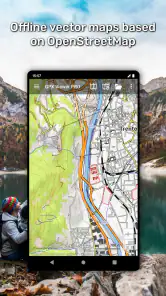
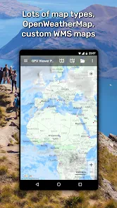
One of the standout features for me has to be the detailed map layers. You can switch between different map types, including satellite, terrain, and hybrid views. This versatility is perfect when you're out in the wild and need a clearer picture of your surroundings. The topographic maps are particularly useful for hikers who need to understand the elevation changes on their routes.
Offline Functionality
Another feature worth highlighting is the offline functionality. Let's face it, mobile data can be spotty when you're adventuring in remote areas. With GPX Viewer PRO, you can download maps in advance and access them without an internet connection. This is a lifesaver when you're on an unmarked trail with no bars on your phone.
More From Our News Desk

Clash of Clans Is Won Between the Battles

Android Auto Makes the Case for Quieter Car Software

MobiOffice: Transforming Mobile Productivity with Seamless Integration

EA SPORTS FC™ Mobile Soccer: Redefining Mobile Sports Gaming

How Microsoft OneDrive Became a Mobile Productivity Giant

How Google Translate Breaks Language Barriers Effortlessly
Real-Time GPS Tracking
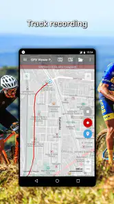
Accurate and real-time GPS tracking is crucial for any navigation app, and GPX Viewer PRO delivers on this front. The app provides precise location data, ensuring you always know where you are on the map. This real-time tracking is crucial for safety, especially when you're exploring unfamiliar territories.
Customizable Waypoints
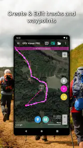
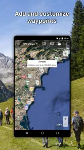
If you love customizing your routes, you'll appreciate the waypoint feature. GPX Viewer PRO allows you to add, edit, and organize waypoints with ease. This means you can tailor your routes to include specific points of interest, rest stops, or scenic views that you want to check out along the way.
How it differs from everyday navigation
I would not choose this as my default app for driving directions or for discovering a new route from scratch. A conventional navigation app is usually the better fit when I need an address search, live traffic decisions, or spoken turn-by-turn guidance. This app makes more sense when the route itself is the thing I care about: I want to open a track someone sent me, see its shape, and keep my location in relation to it. If I do not already have a route file, I would look for a planning tool first and use this viewer when I have something concrete to inspect.
A little preparation pays off
For an offline outing, I would not wait until I reach the trailhead to prepare. I would open the route while I have a connection, verify that its line and waypoints are visible, and make sure the map area I need is available for offline use. A route file and a map are not interchangeable: the file tells me where the planned path goes, while the map gives that path context. Checking both beforehand is a small step that can make a bigger difference than changing map layers once I am already out of signal.
It is also worth treating waypoints as navigation notes rather than decoration. I might use them to mark a junction where the route could be confusing, a planned break, or the point where I intend to turn back. Keeping those markers purposeful makes the screen easier to read while moving. On a shared route, I would inspect the file before relying on it; a line on a map does not by itself guarantee that the path is suitable for my pace, equipment, or current conditions.
Who will get the most from it
I think the clearest fit is a hiker, cyclist, or other outdoor user who regularly receives or keeps route files and wants to view them alongside their position. It can also suit someone who prefers to plan with one service and use a dedicated viewer to check the resulting file. Casual walkers who only need a nearby place search may find that a standard maps app is simpler, while people who expect automatic route creation and comprehensive driving guidance may want a broader navigation app instead.
The app is listed as version 1.49.3 and requires Android 7.0 or later, so those are useful compatibility checks before paying. Its release date is Aug 22, 2017; for my decision, the more practical question is whether the current version works on my device and supports the files I actually use. I would test with a familiar route before making it part of an important trip routine.
In conclusion, GPX Viewer PRO is more than just a navigation app; it's a comprehensive tool for anyone who loves the great outdoors. With its extensive range of features, from file compatibility to offline maps, it ensures that you have everything you need right at your fingertips. So, whether you're a seasoned hiker or a weekend warrior, this app is definitely worth checking out. Trust me, it will make your outdoor adventures a whole lot smoother.
My buy-or-skip take
I would consider the $8.99 purchase worthwhile if I expect to open and follow route files often, especially when the ability to prepare for low-signal areas is part of my routine. If I only need directions occasionally, or mainly want an app to find places and build routes for me, I would skip it and stick with a general navigation option. For the right user, its value is not about replacing every map app; it is about making a saved route easier to understand and follow.
Checking a route before relying on it
One useful habit is to compare the route file with the kind of trip I actually plan to take, rather than assuming the line is a complete set of instructions. If a friend sends a cycling track for a family ride, for example, I would inspect its shape and waypoints before leaving and consider whether the route looks appropriate for the group. A viewer can make the route visible, but the judgment about terrain, pace, and suitability still belongs to me.
I would also keep the original file in a recognizable folder or give it a clear name before a trip. When several versions of a route circulate among friends, opening the wrong one can be more disruptive than any map issue. A quick check of the route’s endpoints and notable waypoints helps me confirm that I have the intended file. This is a small organizational step, but it turns the app into a more dependable part of a repeatable routine.
Making the map easier to read outdoors
Map layers are most useful when I choose them for the question in front of me. A satellite view can help me orient myself around visible landscape features, while a terrain-style view may be more helpful when I want to understand the shape of an outdoor area. I would not keep switching just to explore every option; I would pick the clearest view before moving and change it only when the current one makes the route harder to interpret.
Screen reading is another practical trade-off. When I am walking, I can stop briefly at a junction and compare my position with the route instead of trying to study the display while moving. On a bike, I would be even more cautious and check the map only when safely stopped. That approach makes a route viewer useful without treating it as a substitute for attention to the path, traffic, or surroundings.
What it cannot replace
The app’s focus on viewing route files is also its main boundary. If I want to discover a nearby trail, search for a café, or have a navigation app automatically choose a new route around a closure, a general mapping service is likely to be more convenient. If I want to create a route from scratch, I would first use a service designed for route planning, then open the resulting file here if I wanted a focused view of it.
Even for file-based outings, I would not treat a phone display as the only safety measure. Batteries run down, conditions can change, and a route that looked sensible at home may not suit the day’s weather or my group. For a short familiar walk, the convenience may be all I need; for a remote or demanding outing, I would pair the app with sensible preparation and a backup way to navigate.
Questions I would settle before a trip
If I receive a route in a format I have not used before, I would first test it at home rather than finding out at the trailhead. The app is described as handling GPX and KML files, and the feature discussion also includes KMZ, so trying the actual file in advance is the clearest way to confirm that it opens and displays as expected. I would also check that the route is visible at a useful zoom level and that its waypoints make sense.
For someone wondering whether it can be used without mobile data, the practical answer is to prepare before going offline: open the route and make the needed map area available ahead of time. I would not assume that having the route file alone means every background map will be ready. Likewise, if the main goal is voice prompts or car navigation, I would choose a dedicated turn-by-turn app instead of buying this one for a job it is not centered on.
Who should pay for it
The strongest case for paying is regular use: I already collect GPX or KML routes, I want to inspect them on a map, and I expect to follow them often enough that a dedicated viewer earns its place on my phone. The value is less clear for a person who downloads a route once in a while and already has another tool that displays it adequately. The extra in-app purchases also make it sensible to check what is included and what is optional before deciding what the full cost means for me.
For a casual user, I would start by asking how often route files actually appear in daily life. If the honest answer is rarely, a general maps app may cover ordinary errands and occasional directions with less setup. If route files are part of regular hikes or rides, the dedicated format-focused approach has a clearer purpose. That difference—not the breadth of a feature list—is what would decide the purchase for me.
Final perspective
My recommendation is conditional but straightforward: I would buy it for frequent route-file viewing, and skip it if I mainly want an all-purpose navigation companion. The paid price makes most sense when the app solves a recurring problem, such as checking a shared trail route or keeping track of a saved ride away from reliable reception. Used that way, it is a focused tool rather than a replacement for every map on my phone.
Vectura Games OÜ’s app has been available since Aug 22, 2017, and its current version is 1.49.3. I would still make the decision around my device, the files I use, and the trips I take, rather than relying on its age or popularity alone. Try a familiar route first, prepare the map before setting out, and decide whether that focused workflow is worth the cost for you.
GPX Viewer PRO Frequently Asked Questions
Is GPX Viewer PRO free to download, and are there additional costs?
GPX Viewer PRO is a paid app, listed at $8.99, and it also offers in-app purchases priced from $1.99 to $2.49 per item. Consider both the initial price and those optional purchases when deciding whether it fits your needs. The app is in the Maps & Navigation category and is developed by Vectura Games OÜ.
What file types can I view in GPX Viewer PRO?
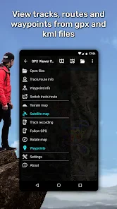
GPX Viewer PRO shows tracks, routes and waypoints from GPX and KML files. This makes it useful if you already have route files and want to inspect their mapped content in an app. Before downloading, check that the files you plan to use are in one of these supported formats, so the app matches your intended workflow.
What is GPX Viewer PRO and what does it offer?
GPX Viewer PRO is a premium navigation and mapping app designed for hikers, cyclists, and adventure enthusiasts. It offers advanced features for viewing GPX and other formats, detailed offline maps, route planning, and track analysis. The app is ideal for exploring new paths without an internet connection, providing users with reliable navigational tools for outdoor activities.
How does GPX Viewer PRO enhance my outdoor adventures?
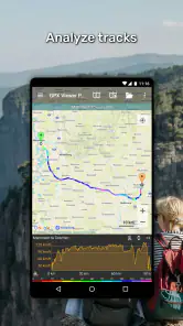
GPX Viewer PRO enhances outdoor adventures by providing a comprehensive suite of tools for navigation and planning. It allows users to import GPX files, view detailed maps offline, and analyze tracks with elevation data. The app's ability to function without an internet connection ensures that users have access to critical navigational information even in remote areas, making it a vital companion for explorers.
Is GPX Viewer PRO suitable for beginners in navigation?
Yes, GPX Viewer PRO is suitable for beginners as well as experienced users. The app features an intuitive interface with easy-to-follow instructions and tutorials for importing routes and navigating maps. Beginners can start with basic functionalities and gradually explore more advanced features like track analysis and route customization, making it a versatile tool for all skill levels.
Pros
- High accuracy in GPS tracking.
- Offline map access available.
- Customizable waypoint features.
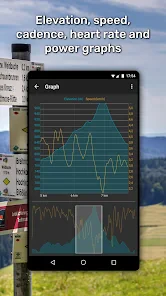
- Detailed elevation profiles.
- Supports multiple file formats.
Cons
- Limited free features.
- Occasional app crashes.
- Steep learning curve for beginners.
- Battery drain during long usage.
- Premium version is costly.
- Category
- Maps & Navigation
- Version
- 1.49.3











