GPS Waypoints Navigator | MAPS
- 722.00
- 4.6
- Installs
- 50.00K
- Price
- $9.99

Screenshots
Analysis by Reviewed
I judge a navigation app by what happens after the first few outings: do I still reach for it, and does it make a familiar activity easier rather than adding another chore? GPS Waypoints Navigator makes the strongest case when I want to keep track of places that are meaningful in the field, then return to them later. It feels less like a replacement for everyday directions and more like a personal location notebook that happens to put those notes on a map.
Who gets value from the first outing
Made by Disciple Skies Software, this Maps & Navigation app is aimed at people who revisit outdoor locations or need to identify spots that are not easy to describe with a street address. Hikers, campers, anglers, and explorers who keep returning to trail junctions or access points are more likely to get lasting value from it than someone who mostly drives between familiar places. A conventional navigation app is usually the better pick for traffic, addresses, and spoken directions through town; this one is more compelling when I want to save a location and find it again on my own terms.
A realistic first outing could be a walk on a trail I have never visited. I would prepare the offline map before leaving, save the trailhead, and mark any junction or landmark that could be useful on the way back. A short, concrete note can turn a pin into something recognizable later: “narrow path beside the wooden sign” is more helpful than a label such as “turn here.” This is a small bit of effort up front, but it makes a saved collection much more useful once the novelty of dropping pins wears off.
A Map Lover's Dream
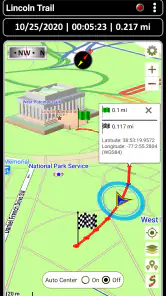
Opening the app, you're greeted with a user-friendly interface that even your tech-averse uncle would appreciate. The main screen is intuitive, displaying a map that's both detailed and easy on the eyes. The GPS Waypoints Navigator integrates seamlessly with various map sources, giving you the flexibility to switch between them depending on your needs. Whether you're on a hiking trail or navigating city streets, this app has got you covered.
Features That Stand Out
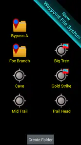
One of the standout features is the waypoint management system. You can easily mark, edit, and delete waypoints, making it a breeze to plan your next adventure. The app also allows for custom notes, so you can jot down that hidden waterfall or the best spot for sunset views. It's like having a digital diary of your travels!
Another cool feature is the ability to share waypoints with friends. Planning a group hike? Simply share the route and ensure no one gets left behind. It's social navigation at its best!
Off the Beaten Path
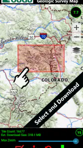
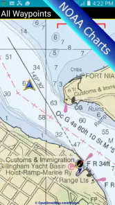
For those who love to venture into the unknown, the app's offline maps are a lifesaver. No signal? No problem! Download the maps beforehand, and you're good to go. This feature is particularly handy for those off-grid adventures where cell service is as elusive as Bigfoot.
More From Our News Desk

Clash of Clans Is Won Between the Battles

Android Auto Makes the Case for Quieter Car Software

MobiOffice: Transforming Mobile Productivity with Seamless Integration

EA SPORTS FC™ Mobile Soccer: Redefining Mobile Sports Gaming

How Microsoft OneDrive Became a Mobile Productivity Giant

How Google Translate Breaks Language Barriers Effortlessly
The Little Things Matter
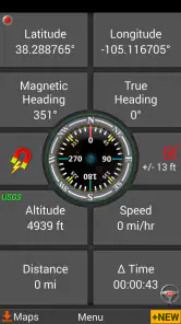
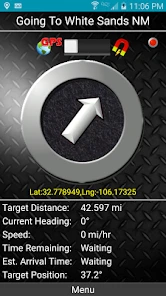
What really sets this app apart are the little extras. From the compass that feels like a sailor's best friend to the sun and moon tracker that helps you plan the perfect camping night, it's the details that make it special. The app even includes a handy GPS status indicator, so you're always in the know about your connection strength.
And let's not forget the customization options. Whether you prefer metric or imperial units, night mode or day mode, the choice is yours. It's all about making the journey yours.
Putting saved places to work
The useful question is not how many locations I can save, but whether I can recognize and act on them later. I would use a consistent naming pattern for recurring trips: put the area or trail name first, then the feature, and reserve the note for details that might change, such as which side of a path a landmark sits on. That makes a collection easier to scan when I am planning the next visit, without requiring a separate spreadsheet or a long cleanup session.
For example, on a weekend walk I might save the parking area, a fork where the trail becomes less obvious, and a viewpoint I want to revisit. On a later trip, those points can help me retrace the useful parts of the outing or explain a meeting place to a friend. The trade-off is that a waypoint is only as useful as its label and context: a cluster of unnamed pins can become confusing, especially if several trips overlap in the same area.
Sharing has a similar practical boundary. A shared location can help a group agree on where to meet, but I would settle the plan before everyone sets off and make sure each person knows what the pin represents. It is not a live substitute for checking on one another, and a location on a map does not resolve what a group should do if someone changes route or loses reception. The best use is simple coordination, not assuming the app can manage the group for you.
Making it a lasting habit
The strongest long-term routine is modest: save only places you expect to use again, add a short identifying note, and review the collection before the next trip. I would also check that the offline map covers the whole planned area before leaving, rather than assuming a download made for one trailhead will cover a longer route. Map preparation is part of the outing, not something to leave until reception becomes unreliable.
One helpful habit is to prepare around the route rather than around a single destination. If I am planning a longer walk, I want the map to cover the path and the places where I might need to make a decision, not merely the point where I expect to start. That is a more reliable way to avoid discovering the edge of a prepared area at an inconvenient moment. I would also make sure the phone is charged before relying on it outdoors; offline mapping removes one dependency on reception, not the need for a working device.
Where the convenience has limits
Offline use depends on doing the preparation in advance, and GPS navigation still asks you to pay attention to your surroundings. I would not treat a phone map as a replacement for sound trail judgement, a charged device or a suitable backup when conditions call for one. If your usual journeys are mostly familiar city routes, maintaining saved waypoints and preparing maps may feel like extra work; a standard navigation app is likely the easier everyday choice.
The same trade-off applies to organization. Notes are valuable only if they are specific enough to recognize later, while saving every passing point can make a collection harder to scan. A simple naming habit—using a trail or area name alongside the landmark—helps keep waypoints useful without turning the app into a catalog you have to constantly tidy.
There is also a difference between having a map available and having a complete navigation plan. I would use the compass and GPS status as useful context, not as permission to stop looking at trail signs or paying attention to terrain. In unfamiliar country, weather, daylight, and route difficulty still matter more than a tidy set of pins. People who need hands-free spoken directions for driving, traffic-aware rerouting, or an effortless address search should keep their usual navigation app as the primary tool.
Paying for repeat use
At $9.99, this is a paid app rather than a casual free download, so I would judge its value by how often I revisit saved places and rely on prepared maps. It has a 4.6 average from around 3,900 ratings, with over 50,000 installs, which suggests an established audience without making it the obvious choice for every phone owner. The Everyone age rating is broad, while the practical fit is narrower: people who go outdoors or manage recurring locations are more likely to benefit than someone who only needs directions to a new restaurant.
The price makes sense to me if the app becomes part of a repeated routine: preparing maps for trips, recording useful locations, and returning to saved spots. If I only go on an occasional walk and already use a free map successfully, the purchase is harder to justify. I would decide based on a realistic question: do I expect to use the saved locations again, or am I mainly attracted by the idea of collecting them? The former is a stronger reason to pay.
Against the usual alternatives, GPS Waypoints Navigator occupies a more specialized role than a general map service. General-purpose apps are convenient for discovering businesses, checking roads, and getting directions to an address. A paper map or a dedicated outdoor navigation setup may suit someone who wants a broader backup plan or prefers not to depend on a phone. This app is the middle ground I would consider when keeping personal waypoints and preparing offline maps are central to my trips, but it is not a one-tool answer to every kind of navigation.
GPS Waypoints is at version 9.32 and runs on Android 5.0 or later. Those details matter if you are installing it on an older device, but I would still check that the phone itself is dependable for the kind of trip you have planned. The release history reaches back to June 28, 2012, and the app has 722 reviews; what matters for a new user is whether the current workflow feels comfortable enough to keep using, not simply how long it has existed.
When the routine starts to feel like work
The main source of fatigue is not using a map on the trail; it is maintaining a useful collection around it. If I save every small detour, temporary meeting place, and passing landmark, I create a sorting problem for my future self. I would be selective and use notes for information that cannot be inferred from the map alone. That keeps preparation short and makes the app more likely to survive beyond a burst of enthusiasm after the first outing.
Another reasonable question is whether it will replace a familiar navigation app. For most people, I would say no. I would keep a mainstream option for daily driving and use this when I care about recording or returning to specific places. Similarly, if I need a navigation tool for an important trip, I would test my own setup before relying on it far from home: prepare the map, save a sample waypoint, and make sure I understand how I will find it again. A brief practice run can reveal whether the workflow suits me before it matters.
Final Thoughts
In the vast world of navigation apps, the GPS Waypoints Navigator stands out not just for its features but for its reliability. Whether you're a casual wanderer or a hardcore explorer, this app provides the tools you need to make the most of your adventures. So, grab your gear, fire up the app, and let the journey begin!
My recommendation is more specific: choose it if you want a lasting record of places and are willing to prepare before heading out. Skip it if you mainly want effortless, live directions for routine driving, or if you dislike organizing locations. For the right person, its value is not novelty but the confidence of finding a meaningful spot again—and that is a reason to keep it installed.
GPS Waypoints Navigator | MAPS Frequently Asked Questions
Who is GPS Waypoints Navigator designed for?
GPS Waypoints Navigator is a Maps & Navigation app for people who want to find trails, organize locations, and navigate with offline maps. Its waypoint-focused tools may appeal to hikers and other outdoor explorers, as well as users who need to save places for later. The app is rated for Everyone, so its content rating is suitable for a general audience.
What features does GPS Waypoints Navigator offer for navigation?
GPS Waypoints Navigator provides a comprehensive set of navigation features including waypoint management, route planning, and real-time location tracking. The app is designed to help users navigate efficiently, whether on foot, driving, or boating. It also supports offline maps, which can be particularly useful in areas with poor internet connectivity. Additionally, users can record journeys, share locations, and utilize various map sources for enhanced versatility.
Is GPS Waypoints Navigator suitable for offline use?
Yes, GPS Waypoints Navigator is highly suitable for offline use. The app allows users to download maps for offline access, ensuring that navigation is possible even without an active internet connection. This feature is especially beneficial for outdoor enthusiasts who may venture into areas with limited or no network coverage. Users can manage and organize their offline maps within the app for easy access during adventures.
How user-friendly is the GPS Waypoints Navigator interface?
The GPS Waypoints Navigator boasts a user-friendly interface designed for both beginners and experienced navigators. The app features intuitive controls and a clean layout, making it easy to manage waypoints, routes, and maps. Tutorials and support documentation are available to assist users in getting the most out of the app. The app's design focuses on simplicity without sacrificing the depth of its features.
What platforms is GPS Waypoints Navigator available on?
GPS Waypoints Navigator is available on both Android and iOS platforms, making it accessible to a wide range of smartphone users. The app is optimized for different screen sizes and devices, ensuring a smooth experience regardless of the device used. Regular updates are provided to keep the app compatible with the latest operating systems and to introduce new features and improvements.
Pros
- Highly accurate GPS tracking.
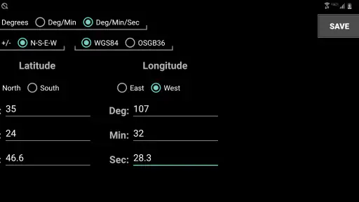
- Supports multiple coordinate formats.
- Offline maps available.
- Customizable waypoint icons.
- Integrated compass feature.
Cons
- Interface feels outdated.
- Limited map style options.
- Consumes significant battery.
- Occasional slow loading times.
- No social sharing features.
- Category
- Maps & Navigation
- Version
- 9.32











