Go To Well
- 40.00
- 3.9
- Installs
- 10.00K
- Price
- Free
Screenshots
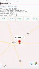
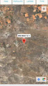
Analysis by Reviewed
If you work around American oil and gas fields, Go To Well is the kind of focused navigation app that can save you from searching through broad map results. I found its purpose easy to understand: it helps you search for, view, and navigate to oil and gas wells in the United States. That narrow focus is also its biggest advantage, because the app is not trying to become a general-purpose travel planner.
My first impression was that this is a practical tool rather than a polished lifestyle app. It belongs in Maps & Navigation, comes from Sunland Software, and is available free of charge. The audience is clearly specialized, but you do not need to be an industry expert to understand the basic workflow. If you need to locate a particular well, inspect it on a map, and begin a route, the app gives you a more direct starting point than manually searching a broad mapping service.
What to expect before you start searching
The most important thing to understand is the app’s scope. It is designed around wells in the United States, not around every kind of destination. That makes it useful for field visits, preliminary planning, checking the position of a known site, or finding a well while moving through an unfamiliar producing area. It is less suitable if your main need is ordinary driving navigation, restaurant discovery, public transport, or international mapping.
I would approach it as a specialist lookup layer that can lead into navigation. A general map app usually starts with addresses, businesses, roads, and landmarks. Go To Well starts with the well itself. That difference matters when a site has a technical name or location that is difficult to identify through a normal place search.
The app is free to install, although in-app purchases are listed at $29.99 per item. I would therefore begin with the free experience and only consider an optional purchase after understanding exactly which part of your workflow it improves. For occasional personal use, paying before testing the basic search would be unnecessary. For repeated professional use, the value depends on whether the paid option supports a task you perform often enough to justify it.
The public reception is mixed but reasonably positive, with a 3.9 average from around 77 ratings and about 40 written reviews. I read that as a reason to keep expectations practical. This is not an app I would choose because of a large community or a long list of extras. I would choose it because its specific purpose matches my task.
It has been available since May 16, 2019, and the current version is 1.145. That history suggests a maintained product rather than a brand-new experiment, but it also means I would not expect the visual style or interaction patterns to match the newest mainstream navigation apps. The content rating is Everyone, so the app is presented as suitable for a broad audience, including people who simply need a clear way to locate a well.
More From Our News Desk

Clash of Clans Is Won Between the Battles

Android Auto Makes the Case for Quieter Car Software

MobiOffice: Transforming Mobile Productivity with Seamless Integration

EA SPORTS FC™ Mobile Soccer: Redefining Mobile Sports Gaming

How Microsoft OneDrive Became a Mobile Productivity Giant

How Google Translate Breaks Language Barriers Effortlessly
Who gets the most value from it
I see three especially sensible audiences. The first is someone who visits wells for work and needs a focused way to identify the correct location before driving. The second is a landowner, researcher, student, or enthusiast who wants to inspect well locations on a map without building a custom data workflow. The third is a driver who already knows the well or field name but needs a practical route to reach it.
For a first-time user, the reassuring part is that the goal is narrow. You do not have to learn a large planning system before doing anything useful. The first meaningful success should be simple: find a well, confirm that the map position looks like the intended site, and start navigation.
I would skip it if you need detailed turn-by-turn trip planning with stops, offline maps, traffic-aware commuting, or a full record of every place you visit. A mainstream navigation app is usually better for those jobs. I would also avoid treating a pin as proof that a road is open, a gate is accessible, or the location is safe to enter. A map position can help you plan, but it does not replace local access knowledge or site rules.
From installation to a useful first visit
Set up the app with a clear search target
Before opening the search screen, I recommend writing down the exact well name, identifier, or location information you already have. This small preparation makes a real difference. Searching vague terms can produce uncertainty, especially in areas where several wells have similar names. A precise starting point gives you something concrete to verify on the map.
After installing the app, I would avoid immediately tapping through every available option. Start by looking for the search function and enter the information you trust most. If you have a well name, begin there. If you have a location or another identifying detail, use that instead. The aim is not to explore randomly; it is to reduce the number of possible results before you begin comparing pins.
When a result appears, take a moment to inspect its position rather than launching navigation instantly. This is one of the most useful habits with a specialized well finder. A result that looks plausible in a list can still be the wrong site if names are similar. Compare the surrounding roads, nearby features, and general area with the information you were given.
The first success is confirmation, not merely a search result. I consider the search complete only when the selected well makes sense on the map and I know why it is the one I want. That extra pause can prevent a long drive toward the wrong location.
Use the map as a verification tool
The map view is more valuable when you use it to ask practical questions. Is the well near the road you expected? Does the surrounding pattern match the field or county you are working in? Is the pin far enough from the main route that you should plan the final approach carefully? These checks turn the app from a simple search box into a preparation tool.
I would also zoom in and out before navigating. A close view helps with the immediate position, while a wider view shows whether you are looking at the correct part of the United States. This is particularly important when several names repeat across different producing regions. The wider context can expose a wrong match before you commit to the route.
Another useful workflow is to use the app before leaving rather than only after you are already on the road. Search while you have time to compare the result with your work notes, then use your usual navigation method for the drive if that gives you better traffic or road guidance. In that arrangement, Go To Well handles the specialized location lookup while your regular map app handles the broader journey.
That combination is often more sensible than forcing one app to do everything. A specialist can be better at identifying the destination, while a general navigation service may be more comfortable for the route itself. I would not see that as a weakness; it is a practical division of labor.
Start navigation only after checking the final approach
Once the well is selected and the position looks correct, use the navigation action to begin the trip. Before following the route, I would check the final approach in the map and compare it with any instructions from the operator, landowner, or field contact. The app can point you toward a site, but the last part of a rural route may involve private roads, restricted access, changing conditions, or a turn that is easy to miss.
This is where first-time users can avoid a common mistake: assuming that the most direct line on a map is automatically the appropriate entrance. A well may be visible on the map while the usable access point is elsewhere. Treat the route as a planning aid and confirm local access separately whenever the visit matters.
For a realistic example, imagine that I need to visit a well in a county I do not know. I would search the identifier at home, select the result, zoom out to confirm the county and nearby roads, then zoom back in to study the approach. I would save the relevant details in my work notes, use the app to initiate navigation, and keep my normal road-safety habits throughout the trip. If the final turn looks uncertain, I would contact the person who supplied the location rather than blindly following the screen.
Where new users may become confused
The first likely confusion is expecting a normal address search. A well is not always presented like a shop or house, and its identifying information may be technical. If your first search is too broad, do not assume the app is useless. Refine the wording, check the region, and compare the map context before deciding that a result is wrong.
The second confusion is the difference between finding a well and being able to reach it. The app’s core job is location and navigation, not permission management or field access. A visible destination does not automatically mean that you may enter the property. This distinction is easy to overlook when the pin appears precise.
The third is assuming that a navigation result settles every road question. Rural routes can be more complicated than urban ones, and the app should not be your only source of information for a sensitive or time-critical visit. Use it to identify and approach the destination, then apply local knowledge for gates, private roads, seasonal conditions, and site instructions.
A fourth point concerns the optional purchases. Because the app is free but lists purchases at $29.99 per item, I would not treat every visible upgrade as essential. First establish whether the free workflow lets you search and navigate to the locations you actually need. If it does, continue using it without paying. If your work requires more, read the purchase description carefully and judge it against your frequency of use.
How it compares with ordinary map apps
Compared with Google Maps, Apple Maps, or another general navigation service, Go To Well has a narrower starting point. That narrowness can be an advantage when a well is the destination and a normal search gives you too many unrelated results. You spend less time translating technical location information into a recognizable place.
General map apps remain stronger for everyday travel. They are the better choice when I need traffic context, restaurants, fuel stops, multiple errands, public places, or a familiar address. I would not replace my regular navigation app with this one for daily driving. Instead, I would use Go To Well when the destination itself is the difficult part.
The trade-off is simplicity versus breadth. A focused well map can make a specialized lookup feel direct, but it cannot replace the broader ecosystem around ordinary navigation. The best choice depends on where the uncertainty is: if I am unsure which well I need, I start here; if I already know the destination and need the smoothest road trip, I use my usual mapping tool.
Practical habits that make the app more dependable
My first tip is to confirm the region before trusting a matching name. Repeated names are a real-world problem in location searches, and the map’s wider context is your quickest check. My second tip is to separate destination verification from route following. Confirm the well first, then decide whether this app or another navigation service is better for the drive.
My third tip is to keep a written or digital note of the identifier you searched. That makes it easier to explain your destination to a colleague and easier to repeat the search later. It also reduces the risk of selecting a similarly named result on a later visit.
My fourth tip is to plan the final approach before leaving cellular coverage or entering a remote area. I would not assume that any navigation app guarantees offline access simply because it displays a map. Prepare the information you need while connected, and carry any site directions that are important to the visit.
Finally, treat the pin as one piece of evidence. Match it with your work order, field notes, local directions, and access instructions. This is especially valuable when a wrong turn could cost significant time. The app can shorten the search process, but good field preparation still matters more than a single screen.
Performance expectations and device fit
The current release is version 1.145 and requires Android 6.0 or later. That makes it accessible to many older Android devices, which is useful if you keep a dedicated work phone rather than upgrading frequently. I would still test the app on the actual device you plan to carry into the field, because screen size, battery condition, and network reliability can affect the experience more than the minimum operating-system requirement.
The install base is over 10 thousand, so it is a specialized product rather than a mass-market navigation standard. That is not automatically negative. A smaller audience can simply reflect the narrow purpose. It does mean I would be more deliberate about testing the search workflow with one or two real locations before depending on it for an important appointment.
Since the app is rated for Everyone, it does not present itself as restricted to industry professionals. Still, the usefulness of the information depends on how well the user understands the destination and the access situation. A beginner can operate the basic search-and-navigation flow, but a beginner should not confuse easy operation with complete field guidance.
My recommendation for a first-time user
I would recommend installing Go To Well if you have a genuine need to locate oil and gas wells in the United States and you want a dedicated starting point. The path to value is short: search a precise identifier, inspect the map, verify the surrounding area, and begin navigation only after checking the final approach.
I would not recommend it as a universal replacement for a standard map app. Its strength is specialization, and its limitations come from that same focus. If your destinations are ordinary businesses, homes, public facilities, or multi-stop trips, a broader service will probably feel more natural. If your destination is a well and the hard part is finding the correct one, this app is much easier to justify.
After using it, my view is that Sunland Software has built a useful tool for a clearly defined problem. The free entry point makes it easy to test, while the optional $29.99 purchases deserve a careful decision based on actual need rather than curiosity. I would start with one known well, verify the complete workflow, and only then decide whether it belongs in my regular field toolkit.
For me, the app’s real value is not that it replaces every navigation tool. It is that it helps turn a specialized well reference into a destination I can investigate and approach. Used with sensible map checking and local access information, Go To Well can make the first step toward a field location much less confusing.
Go To Well Frequently Asked Questions
What is Go To Well, and what can I use it for?
Go To Well is a wellness-focused app designed to help users organize and improve everyday health habits. Depending on the features available in your version, it may provide access to wellness content, activities, progress tracking, reminders, or guidance related to physical and mental well-being. It is best viewed as a practical self-care companion rather than a replacement for professional medical advice.
Is Go To Well free to download and use?
Go To Well may be available to download at no initial cost, but some features, programs, content, or personalized services could require registration, a subscription, or an in-app purchase. Before confirming payment, review the pricing details, trial conditions, renewal policy, and cancellation instructions shown in the app store or inside the application. Availability can also vary by country and platform.
Do I need to create an account to use Go To Well?
An account may be required to access the complete Go To Well experience, especially if the app saves progress, synchronizes information across devices, delivers personalized recommendations, or connects users with a wellness program. Some basic sections might be accessible without signing in. Check the permissions and information requested during registration, and use a strong password if personal health-related details are stored.
Is Go To Well suitable for everyone, including people with medical conditions?
Go To Well can be useful for general wellness and habit-building, but users with injuries, chronic illnesses, pregnancy-related concerns, or other medical conditions should be cautious when following any exercise, nutrition, or lifestyle guidance. The app should not be used to diagnose symptoms or replace a doctor, therapist, or other qualified professional. Stop any activity that causes discomfort and seek appropriate medical advice.
What personal information and permissions does Go To Well require?
The information and permissions requested by Go To Well depend on the features you use and the operating system on your device. The app may request details such as an email address, profile information, activity data, notifications, or health-related inputs. Before downloading, review its privacy policy and the store listing. You can also check device settings and disable permissions that are not necessary for your preferred use.
Pros
- Simple interface makes wellness content easy to browse and use.
- Offers practical guidance for building healthier daily habits.
- Suitable for users with different wellness experience levels.
- Can provide convenient support without requiring in-person appointments.
- Useful for checking in with personal goals and maintaining motivation.
Cons
- Some features may require an account or personal information.
- Content variety may feel limited for users seeking advanced programs.
- Progress tracking may not offer enough detail for serious athletes.
- Wellness advice may not replace guidance from qualified professionals.
- Availability of features can vary depending on device or region.
- Category
- Maps & Navigation
- Version
- 1.145











