Gaia GPS: Offline Trail Maps
- 3.77K
- 3.2
- Installs
- 1.00M
- Version
- 2025.7
Screenshots


If you're an outdoor enthusiast like me, finding the perfect app to aid your adventures is like hitting the jackpot. Enter Gaia GPS: Offline Trail Maps, your new best friend for all things hiking, biking, or any outdoor escapade you can dream of. I recently took this app for a spin and was pretty stoked with the experience. Let me break it down for you.
Exploring the Great Outdoors with Confidence
First off, what really caught my eye with Gaia GPS: Offline Trail Maps is its offline capabilities. Imagine being out in the wilderness, miles away from cell service, and still having access to detailed maps and trails. This app lets you download maps ahead of time, so you're never left in the lurch. I tried this on a recent hike, and trust me, not having to worry about connectivity was a game-changer.
Feature-Packed for Every Adventurer
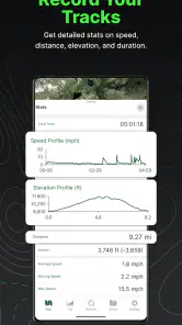
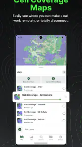
Now, let's talk features. This app is not just about maps. It's a whole toolkit for the outdoors. The app offers topographic maps, satellite imagery, and even weather updates. For someone who likes to plan hikes meticulously, having all this info in one place is a dream. And hey, if you're a data geek, you'll love the tracking feature. It logs your route, speed, elevation, and more. I found this particularly useful to review my trail performance and plan future trips.
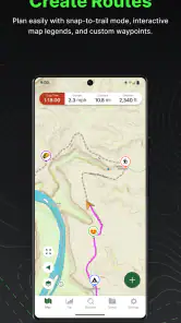
One of the standout features for me was the ability to customize routes. You can plan your path, adjust waypoints, and even share it with your buddies. It's like having a mini expedition planner in your pocket. Plus, you can track your friends' locations in real-time, which adds a layer of safety and fun to group adventures.
User Experience and Design
The app's design is sleek and intuitive. Navigating through its features is pretty straightforward, even for a non-tech savvy person like me. I appreciated the clean interface that doesn't overwhelm with options but still offers everything you need. The vibrant map layers are easy to read, and switching between them is seamless. The developers clearly put thought into making it user-friendly, which is a huge plus.
However, a minor hiccup I encountered was the initial learning curve. With so many features packed into one app, it took me a bit to get the hang of everything. But once you dive in, it's smooth sailing.
Why You Should Give It a Go
In a nutshell, if you're serious about your outdoor adventures, Gaia GPS: Offline Trail Maps is worth checking out. It's like having a Swiss Army knife for navigation in your pocket. The offline capabilities alone make it a must-have. So next time you're gearing up for a trek, consider giving this app a whirl. It might just become your new favorite trail companion.
Remember, the wild is calling, and with this app, you’re more than ready to answer.
Pros
- Extensive offline map availability.
- User-friendly interface and navigation.
- Comprehensive trail information.
- Frequent updates with new features.
- Customizable map layers.
Cons
- Premium features require subscription.
- Occasional GPS inaccuracies.
- Limited social features.
- Battery consumption can be high.
- Steep learning curve for beginners.