DeFlock.me
- 184.00
- 4.6
- Installs
- 100.00K
- Price
- Free

Screenshots
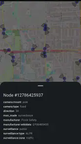
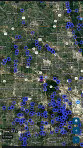
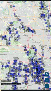
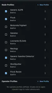
Analysis by Reviewed
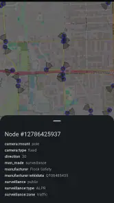
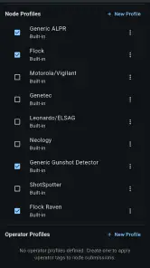
I tried DeFlock.me as a community-focused navigation app built around one very specific concern: identifying mass-surveillance infrastructure and helping people make more informed choices about the roads they use. That makes it quite different from a conventional map app. It is not mainly about finding the quickest route, checking opening hours, or replacing a full turn-by-turn navigator. Its purpose is more focused, and that focus is exactly what makes it interesting.
Developed by TechBS, the app sits in the Maps & Navigation category and is available free of charge. It is suitable for Everyone, works on devices running Android 7.0 or later, and has reached over 100 thousand installs. The current release is version 2.11.0. Those details make it relatively accessible, especially for people using an older Android phone who want to explore the subject without paying for another subscription.
My overall impression is that this is best understood as a public-awareness and mapping tool rather than a replacement for Google Maps, Apple Maps, or a dedicated driving app. If you care about privacy, local observation, and contributing useful information about surveillance equipment, it offers a practical way to do that. If you simply want the fastest route to a restaurant, it is probably not the app I would open first.
What DeFlock.me actually adds to everyday navigation
The central idea is simple but more useful than the short store description might suggest. Instead of treating the road network as a neutral background, DeFlock.me draws attention to infrastructure that can affect how movement is observed in a community. That changes the question from “How do I get there?” to “What is present along the way, and what do I want to know about it?”
I found that distinction important because ordinary navigation apps are designed around convenience. They prioritize traffic, estimated arrival times, road closures, and business locations. DeFlock.me addresses a different layer of the journey: awareness of surveillance-related installations and the ability for users to report what they encounter. It is therefore more useful as a companion to a normal map than as a total replacement for one.
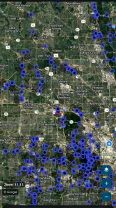
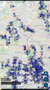
The app’s strongest appeal is its community element. A map becomes more valuable when people do more than look at it. They can inspect information near familiar streets, notice patterns in their wider area, and contribute observations that may help other users understand what is happening around them. That makes the experience feel less passive than browsing a standard map.
There is also a practical benefit to separating this information from a general-purpose navigation service. A conventional map can become visually crowded with restaurants, shops, transit stops, reviews, and traffic overlays. A focused tool can make one issue easier to examine. For someone researching local surveillance infrastructure, preparing a neighborhood discussion, or simply wanting to understand a regular commute, that focus is more useful than a long list of unrelated map markers.
More From Our News Desk

Clash of Clans Is Won Between the Battles

Android Auto Makes the Case for Quieter Car Software

MobiOffice: Transforming Mobile Productivity with Seamless Integration

EA SPORTS FC™ Mobile Soccer: Redefining Mobile Sports Gaming

How Microsoft OneDrive Became a Mobile Productivity Giant

How Google Translate Breaks Language Barriers Effortlessly
How I would use it before and during a trip
I would not begin by replacing my usual navigation app. Instead, I would check DeFlock.me before leaving home, especially when traveling through an unfamiliar district. Looking at the area in advance gives me time to understand what has been reported without trying to interpret a specialized map while driving. I would then use my normal navigation tool for directions and keep DeFlock.me available for a more deliberate look at the route.
A realistic everyday example would be a regular bicycle commute. Before choosing between two similar roads, I could inspect both areas and consider the information shown by the app alongside practical factors such as traffic, road quality, and comfort. The app would not make that decision for me, and it should not be treated as a safety guarantee, but it could add a privacy-related consideration that ordinary route planning leaves out.
For a driver, the sensible workflow is even more clearly divided. Review the map while parked, decide whether the information affects your route, and avoid interacting with the phone while moving. That may sound obvious, but specialized maps invite closer inspection than a simple turn prompt. DeFlock.me is more valuable when used calmly before a journey or after arriving, not when someone is trying to study every marker in traffic.
Another useful workflow is local verification. If I notice equipment that appears relevant to the app’s purpose, I can compare the physical location with what is shown and consider whether a report would improve the map. The important trade-off is accuracy: a rushed or mistaken report can be less helpful than no report at all. I would record only what I can identify responsibly, avoid guessing about ownership or purpose, and treat the map as a community information resource rather than an official legal record.
Reporting is more than tapping a marker
The reporting side is where the app can become genuinely valuable, but it also asks more from the user than ordinary navigation. A person who only wants to consume information can browse the map. A person who wants to improve it needs to slow down, observe carefully, and distinguish a confirmed sighting from an assumption.
That creates a subtle strength: the app encourages a more attentive relationship with the local environment. Instead of assuming that every visible camera or roadside device has the same function, I would approach the process with caution. Location, appearance, road position, and context all matter. Even when the app makes reporting easy, the quality of the community map depends on users resisting the temptation to submit uncertain details.
There is a useful privacy habit here as well. I would avoid including unnecessary personal information in any contribution, particularly details about private homes, identifiable people, or routines. The most helpful report is focused on the relevant infrastructure and its location, not on the individual who happened to notice it. That is a non-obvious part of using a privacy-oriented app responsibly: the act of documenting a concern should not create a new privacy concern.
I would also revisit information rather than assuming that one glance settles the matter permanently. Infrastructure can change, reports can be incomplete, and community maps depend on ongoing attention. DeFlock.me is most helpful when I treat it as a living reference for investigation and discussion, not as an infallible authority.
What the free price means in practice
The free price is a meaningful advantage. There is no purchase decision standing between a curious user and the app’s central experience, so it is easy to test without committing money. That matters for a specialized tool because not everyone will know in advance whether this kind of map is relevant to their daily life.
Free access also suits the app’s community purpose. The more easily people can inspect local information and contribute responsibly, the more useful the service can become. I would still judge its value by usefulness rather than by the absence of a price tag. A free app that I open once and forget has little practical value; a focused tool that changes how I research a route or understand my neighborhood can be worthwhile even when it is not used every day.
In this case, the value comes from access to a specialized perspective. DeFlock.me does not need to replace a paid navigation package to justify installing it. Its role is narrower: it gives privacy-conscious users a dedicated place to examine and report a particular kind of infrastructure. That makes the free model especially attractive for occasional research, community work, or personal curiosity.
I would not interpret “free” as a promise that it can answer every navigation need. It remains sensible to keep a general map app for directions, traffic, transit, and places. The strongest value comes from combining tools according to their strengths rather than expecting one app to do everything.
Where it differs from ordinary map alternatives
Google Maps and Apple Maps are built for broad coverage and everyday convenience. They are better choices when I need dependable directions, business information, traffic context, or a familiar interface for a routine trip. Their advantage is breadth. DeFlock.me’s advantage is concentration: it gives one subject much more attention than a general map normally would.
A privacy-focused user may also compare it with a privacy-oriented general map service. Such alternatives can be preferable when the main goal is reducing dependence on large platforms while still receiving ordinary route guidance. DeFlock.me makes more sense when the specific concern is surveillance infrastructure and community reporting. The choice is therefore not simply about which map is “best”; it depends on whether I need navigation first or investigation first.
It is also different from a static article, advocacy page, or social-media discussion. Those sources may explain the wider issue, but a dedicated map can connect the subject to actual streets and local observations. The trade-off is that a map requires more interpretation. A written explanation can provide context in one place, while DeFlock.me is more useful for exploring locations and thinking through what they mean in practice.
I would be cautious about using it as evidence by itself. A marker or report can be a starting point for research, but it should not automatically be treated as proof of intent, legality, ownership, or current operation. That limitation is not a flaw unique to this app; it is a normal challenge for community-maintained location information. The app is strongest when it supports questions and verification, not when it is used to make sweeping conclusions from a single entry.
Small frictions that affect the experience
The specialized focus can feel narrow if my interests are purely practical. Someone opening a map to find fuel, compare travel times, or receive spoken directions may find the app less immediately useful than a mainstream alternative. Its purpose is not broad enough to cover every part of a journey, and trying to force it into that role would make the experience frustrating.
There is also a learning curve in interpreting reports responsibly. A general navigation marker usually answers a straightforward question such as where a shop or road is located. A surveillance-related marker can raise additional questions: what exactly is being identified, how current is the information, and what conclusions are justified? I appreciate that this encourages care, but it means the app rewards thoughtful users more than people looking for instant answers.
Community reporting brings another trade-off. It can reveal information that would otherwise be difficult to gather in one place, but it can also reflect uneven participation. One neighborhood may have attentive contributors while another has fewer reports. I would therefore avoid assuming that a quiet map area is necessarily free of relevant infrastructure. A lack of visible information is not the same as confirmation that nothing is present.
The app’s compatibility with Android 7.0 or later is helpful for accessibility, particularly for people who keep older devices in service. At the same time, anyone using an older phone should expect the general limitations that come with aging hardware, such as a smaller display or slower map interaction. That is not a criticism of the app itself, but it can affect how comfortable detailed map inspection feels.
Who will get the most from it
I think DeFlock.me is a strong fit for privacy advocates, local researchers, journalists, neighborhood organizers, and people who want to understand how observation technology appears in public spaces. It can also suit technically curious users who enjoy contributing structured information rather than merely reading about an issue.
It may be especially useful for someone who travels repeatedly through the same area. Familiarity makes it easier to notice changes, compare routes, and recognize when a report deserves a closer look. A commuter, cyclist, or pedestrian can use the app as a regular research companion without needing it to provide every conventional navigation feature.
The app is also approachable for a first-time user because the price does not create a financial barrier, and its Everyone rating makes it suitable for a broad audience. Still, “accessible” does not mean “effortless.” Younger users and families should discuss responsible reporting, personal safety, and the difference between observing public infrastructure and confronting people at a location.
I would recommend skipping it if I only wanted a polished all-purpose navigator. It is also a poor fit for anyone unwilling to verify observations or tolerate uncertainty in community-sourced information. If the subject itself does not matter to me, the app’s narrow focus will probably feel unnecessary rather than useful.
My verdict after weighing usefulness against effort
The app has earned a 4.6 average from around 400 ratings, with over 100 reviews, which suggests that its focused purpose resonates with a meaningful group of users. I would not treat those figures as a substitute for personal testing, but they fit my impression: this is a specialized tool with a clear audience, not a universal map designed for everyone.
My recommendation is to install it if I want a free way to explore and report surveillance-related infrastructure in my community. The best results come from using it before or after a trip, checking information carefully, and pairing it with a regular navigation app when I need directions or traffic guidance. That combination respects what each tool does well.
I would skip it when my needs are limited to turn-by-turn travel, business searches, or quick route planning. In those situations, a mainstream map will be faster and more complete. But for someone who wants to look at the built environment through a privacy lens, the free access makes experimentation easy, while the community-reporting model gives the app value beyond a normal map.
For me, the final decision is a clear conditional yes. DeFlock.me is not a replacement for everyday navigation, and it should not be treated as a definitive authority on every mapped location. It is better as a focused companion: a way to inspect local infrastructure, ask more informed questions, and contribute carefully considered observations. If that is the kind of map I have been looking for, TechBS has made a worthwhile tool available without a purchase barrier.
DeFlock.me Frequently Asked Questions
Does DeFlock.me work on my Android device?
DeFlock.me is a Maps & Navigation app for Android, and it requires Android 7.0 or later. Check your device’s Android version before downloading; if it meets that requirement, you can install the app from an official app store. The app is intended to help people find, report, and avoid mass surveillance infrastructure in their community.
What is DeFlock.me and what does it do?
DeFlock.me is a privacy-focused service designed to help users identify and understand online tracking and surveillance risks. It provides information about trackers, data collection, and privacy-related technologies, helping you make more informed decisions about the websites, apps, and services you use. Its usefulness depends on the specific tools and features available in the current version.
Is DeFlock.me free to use?
DeFlock.me may provide access to some features without payment, while other tools or advanced functions could depend on the platform, service model, or future updates. Before downloading or signing up, check the official listing and the developer’s website for current pricing, subscriptions, limitations, and supported platforms. Avoid assuming that every privacy feature is included at no cost.
Does DeFlock.me protect my identity or make me completely anonymous?
No privacy tool can guarantee complete anonymity on its own. DeFlock.me can help you learn about tracking and improve your awareness of digital privacy, but it should not be treated as a replacement for secure passwords, multi-factor authentication, careful browsing habits, updated software, or a reputable VPN when appropriate. Always review the app’s permissions and privacy policy before using it.
What information does DeFlock.me collect?
The information collected can vary according to the version, platform, and features you use. It may include technical details, diagnostic data, account information, or usage information required to operate the service. Because privacy is the main reason many people consider DeFlock.me, read its current privacy policy and app-store disclosures carefully to understand data retention, sharing practices, analytics, and deletion options.
Pros
- Helps users spot nearby license-plate surveillance cameras.
- Crowdsourced reports can improve awareness of local privacy risks.
- Simple map-based interface makes camera locations easy to explore.
- Useful for planning routes with fewer potential tracking points.
- Supports broader discussions about privacy and surveillance.
Cons
- Coverage may be incomplete or outdated in less active areas.
- Location accuracy depends on user-submitted reports.
- Some features may be less useful outside supported regions.
- Maps and camera data can consume mobile data and battery.
- Reports may require verification before they can be fully trusted.
- Category
- Maps & Navigation
- Version
- 2.11.0











