DC Metro & Bus: WMATA Realtime
- 2.31K
- 2.8
- Installs
- 500.00K
- Price
- Free

Screenshots
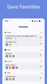
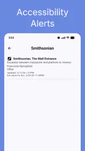
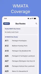

Analysis by Reviewed
I came away from DC Metro & Bus: WMATA Realtime with a fairly clear impression: it is a focused tool for people who regularly move around Washington, D.C. by rail and bus, but it is not the kind of all-purpose navigation app I would install as my only travel companion. Its value comes from putting local transit information in one place, especially when I need to check a train arrival, think through a bus connection, or look at the network on an interactive map. Its weakness is equally important: the modest 2.8 average from around 7,300 ratings suggests that the experience has not been consistently smooth for everyone.
The app is free to download, with optional purchases ranging from $1.99 to $23.99 per item. That makes it easy to try without committing money first. It is rated for Everyone, and it runs on Android versions from 8.0 onward. Dixon Mobility, LLC is the developer, and the app has been available since October 20, 2012, so this is an established local transit product rather than a brand-new experiment.
What the app does well for everyday Metro and bus trips
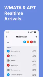
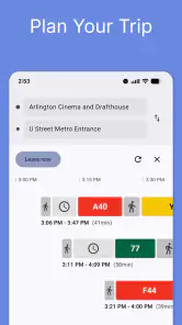
The best reason to use this app is concentration. Instead of opening a broad mapping service and filtering through walking, driving, cycling, and transit options, I can approach the trip from a Washington transit perspective. The combination of real-time DC Metro train arrivals, bus tracking, trip planning, and an interactive map gives the app a practical rhythm: check what is coming, understand where it is, then decide how to get there.
That workflow matters most when a trip is already in motion. Before leaving home, I might use the planner to compare a direct rail journey with a rail-and-bus connection. Once I am near a station, the arrival view becomes more useful than a general route overview because my immediate question is not “How do I reach the city?” but “Which train should I take, and how long might I wait?” For a bus journey, the tracker can help me avoid standing at a stop without a sense of whether the next vehicle is approaching.
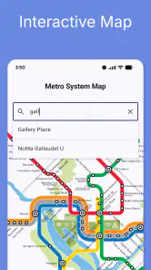
The interactive map is also more than decoration. I find maps valuable when a route looks simple in text but confusing on the ground. A map can reveal that a station entrance, bus stop, or transfer point is not positioned exactly where a casual glance at a street address might suggest. It also helps me understand the shape of a journey before I commit to it, especially when I am unfamiliar with a neighborhood or changing between rail and bus.
The strongest feature is the way live information and route planning support different moments of the same trip. Planning answers the broad question, while arrivals and tracking answer the immediate one. Many navigation apps handle the first job well but make the second feel buried. This app is more appealing when local transit timing is the reason I am opening it in the first place.
A realistic trip where the focused approach helps
Imagine I am leaving a downtown office for an appointment across the District during a busy part of the day. I know the general direction, but I do not want to assume that the first train or bus shown in a static schedule will be the one I actually catch. I can use the map to orient myself, use the trip planner to establish a route, and then check the live arrival information before walking to the platform or stop.
More From Our News Desk

Clash of Clans Is Won Between the Battles

Android Auto Makes the Case for Quieter Car Software

MobiOffice: Transforming Mobile Productivity with Seamless Integration

EA SPORTS FC™ Mobile Soccer: Redefining Mobile Sports Gaming

How Microsoft OneDrive Became a Mobile Productivity Giant

How Google Translate Breaks Language Barriers Effortlessly
If the first option involves a transfer, I would pay attention to the connection rather than simply accepting the fastest-looking result. A route that saves a few minutes on paper may be stressful if the transfer depends on a very short window. In that situation, the app is most useful as a decision aid: I can compare a simpler route with a quicker but less forgiving one and choose based on how much uncertainty I am willing to accept.
For a bus rider, the same process works in reverse. I can first locate the stop on the map, then use the tracker to judge whether leaving immediately makes sense. If the vehicle is not close, I might use the planner to see whether a nearby rail station or another bus connection offers a better alternative. That is a more practical use than treating the app as a passive timetable.
Small habits that make the app more useful
I would not open the app only after stepping outside. My better habit is to check the route early enough to notice transfers and then check arrivals again shortly before departure. Transit conditions can change while I am getting ready, and a route that looked convenient several minutes ago may no longer be the best choice.
I also recommend using the map to verify the physical side of a journey, not just the line names. When I am meeting someone at a station or bus stop, the correct entrance and the correct side of the street can matter as much as the route itself. Using the map before walking reduces the chance of arriving at the right general area but the wrong boarding point.
A third useful habit is to treat the planner as a comparison tool rather than an unquestionable answer. I would check at least one alternative when a trip includes a transfer, particularly if I have luggage, an appointment, or a reason to avoid unnecessary walking. The app can help me see options, but I still need to apply common sense about the time of day, the amount of walking, and how much schedule risk I can tolerate.
These habits also expose an important trade-off. A local transit app can be quicker and more relevant than a general mapping service for Metro and bus information, but it may not replace the broader context those services provide. If I need detailed walking directions through an unfamiliar area, a larger navigation platform may be more comfortable. If my main concern is the local transit network itself, this focused app is easier to approach.
Where the experience becomes less convincing
The rating is the clearest warning sign. With around 2,300 written reviews and more than 500,000 installs, the app has attracted a substantial audience, yet the overall average remains 2.8. I would not ignore that when deciding whether to rely on it for an important journey. A transit tool has a narrow job, and reliability or clarity problems are especially noticeable when the user is already waiting at a stop or trying to make a connection.
I cannot treat a real-time label as a guarantee that every arrival estimate will perfectly match what happens on the street. Live transit information is useful precisely because it changes, but that also means I should leave room for delays, updates, and imperfect predictions. I would use the app to improve my decision, not as permission to plan an appointment around the last possible minute.
The app may also feel too specialized for occasional visitors who want one application to cover every part of a trip. Someone visiting Washington for a weekend may prefer a general map that combines transit with walking directions, places, and broader travel planning. This app makes more sense when DC Metro and bus information is the center of the task rather than one small part of it.
There is another practical consideration in the optional purchases. The initial download is free, but the presence of in-app items means I would look carefully at what is included before assuming every useful function costs nothing. I would begin with the free experience and only consider a purchase if it solves a specific problem I encounter repeatedly. For a visitor making a few trips, paying for extras may be harder to justify than it is for a daily commuter.
Who should install it, and who should choose something else?
I think the strongest audience is a Washington resident, student, worker, or frequent visitor who uses both rail and bus and wants local transit information close at hand. The app is especially suitable for people who already understand the broad network but need help with the next departure, a connection, or the location of a stop. Its focused design can save time because it starts from the transit question rather than making me build that context from scratch.
It is also a reasonable choice for someone who dislikes relying on a printed schedule or a static route diagram. The combination of planning and live information encourages a more flexible approach. I can check the route before leaving, reassess it near the station, and use the map when the physical layout is unclear.
I would be more cautious about recommending it as the only app for a first-time tourist. A visitor who needs restaurant discovery, detailed walking guidance, driving alternatives, or a broad city guide will probably be better served by a general navigation application alongside a transit-specific tool. I would also hesitate to make it the sole source for a time-critical trip until I had personally learned how well its updates matched my usual routes.
For commuters, the decision depends on routine. If I travel on the same line every day, I may value a quick arrival check more than a full trip-planning system. If my work sends me to different parts of the region, the planner and map become more important. In either case, I would keep a backup way to verify a critical journey, particularly when a missed connection would have serious consequences.
Compatibility, cost, and practical expectations
The current version is 4.0.62, and the minimum Android requirement is 8.0. That covers many still-used devices, although anyone with an older phone should check compatibility before planning around it. Because the app is free to start, testing it on a normal route is the sensible first step. I would try the journeys I actually make rather than judging it only from a short walk around the neighborhood.
The Everyone content rating makes the app suitable for a broad audience, including families and younger users who need transit information. That rating does not remove the need for ordinary travel awareness, of course. A child or inexperienced rider may still need help interpreting transfers, choosing the correct platform, and handling a delayed service.
I would also pay attention to how much information I need on screen at once. Transit apps can become frustrating when a user is trying to read a route while walking or standing in a crowded station. My approach would be to plan before moving, then use the arrival or tracking view for a quick confirmation rather than trying to study the entire journey in motion.
My final take on this local transit companion
DC Metro & Bus: WMATA Realtime has a sensible purpose and, at its best, a useful sequence: plan the trip, inspect the network, then check what is arriving now. That makes it more valuable than a simple route diagram for people who depend on Washington rail and bus services. I particularly like the opportunity to compare a planned journey with the immediate reality at a station or stop.
Still, I would not describe it as an automatic recommendation for everyone. The 2.8 average is significant, and the app’s usefulness depends on how dependable and understandable it feels during the routes I personally take. The free starting point lowers the risk, while the optional purchases make it sensible to test before spending anything.
My recommendation is therefore specific: install it if DC Metro and bus travel is a regular part of your life, use the map and planner before you leave, and treat live arrivals as guidance rather than an absolute promise. Pair it with a broader navigation option if you need extensive walking or city information. For a dedicated local transit role, it is worth trying; for a complete travel solution, I would look elsewhere or use it as one part of a larger setup.
DC Metro & Bus: WMATA Realtime Frequently Asked Questions
Is DC Metro & Bus: WMATA Realtime available for my phone?
The app is available for Android and iOS, and its minimum operating-system requirement is version 8.0. Before downloading, check that your device meets this requirement and that you are using the official app from Dixon Mobility, LLC. The app is categorized under Maps & Navigation and is intended for people who need transit information around Washington, D.C.
What is DC Metro & Bus: WMATA Realtime?
DC Metro & Bus: WMATA Realtime is a transit companion app for navigating Washington, D.C.’s Metrorail and Metrobus system. It is designed to provide practical travel information such as station details, route planning, service updates, and estimated arrival times. The app is especially useful for commuters, visitors, and anyone who wants to check transportation options before leaving or while already traveling.
Does the app show real-time Metro and bus arrival information?
Yes, the app is intended to display live or near-real-time arrival information for participating WMATA rail stations and bus stops. After selecting a station or stop, users can typically view upcoming trains or buses and compare expected arrival times. Accuracy depends on the data supplied by WMATA, the current service situation, and your internet connection, so displayed times should be treated as estimates rather than guaranteed schedules.
Can DC Metro & Bus: WMATA Realtime help plan a complete trip?
The app can be helpful for checking routes, stations, stops, and upcoming departures, making it easier to organize a trip across Washington, D.C., Maryland, and Virginia. Depending on the selected feature and app version, it may support route-planning information or help users combine rail and bus services. Travelers should still review alerts and transfer details, particularly during late-night travel, weekends, or planned maintenance.
Does the app require an internet connection or access to my location?
An internet connection is generally needed to retrieve current arrival predictions, service alerts, and other updated transit information. Location access may improve convenience by helping identify nearby stations or bus stops, but it is not always essential if you search manually. If permissions are denied, core information may still be available, although finding nearby transit locations and planning on the move can be less convenient.
Pros
- Live train and bus arrival predictions help reduce waiting time.
- Covers the entire WMATA Metrorail and Metrobus network.
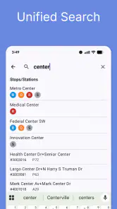
- Station and stop information is easy to find while traveling.
- Useful service alerts can help you avoid delays and disruptions.
- Lightweight design works well for quick checks on the go.
Cons
- Prediction accuracy can drop during service disruptions or bad weather.
- The interface may feel dated compared with newer transit apps.
- Requires location or manual searching to find nearby stops.
- Limited trip-planning features compared with full navigation apps.
- Some information depends on an active internet connection.
- Category
- Maps & Navigation
- Version
- 4.0.62











