CAT Scale Locator
- 88.00
- 4.1
- Installs
- 100.00K
- Price
- Free

Screenshots
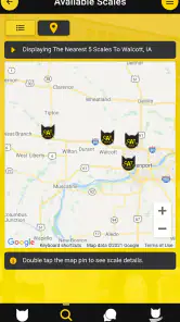
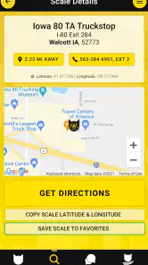
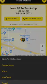
Analysis by Reviewed
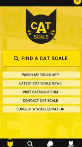
When I first opened CAT Scale Locator, I understood its purpose almost immediately: it helps drivers find the nearest CAT Scale location from an Android phone. That narrow focus is also its biggest strength. This is not trying to replace a full navigation suite, plan a scenic route, or become an all-purpose travel companion. It is a practical tool for a very specific moment, especially when a truck, trailer, or other loaded vehicle needs to be weighed at a CAT Scale.
My first impression was that the app is most useful when I treat it as a starting point rather than a complete trip planner. It points me toward the relevant scale location, while my usual maps app handles the broader journey, traffic, road restrictions, and turn-by-turn directions. That division of labor makes sense. I would not install it expecting a replacement for a general navigation app, but I can see why a driver would keep it available for recurring scale stops.
How useful is CAT Scale Locator after the first week?
The first-week appeal comes from removing a small but annoying search task. Instead of opening a general map service and trying to remember the exact wording for a CAT Scale, I can use a purpose-built locator. The store summary describes it as finding the nearest locations from an Android device, and that focused approach is easy to understand even before spending much time with it.
That simplicity matters most when I am already preparing for a weigh-in. A driver may know the general direction of travel but not the closest suitable location. A dedicated locator reduces the chance of searching for an unrelated business with a similar name or scrolling through map results that require extra checking. It is a modest convenience, but useful tools often earn their place by eliminating small sources of friction.
A realistic example is a driver approaching a new town with a loaded trailer and needing a scale before continuing. I would use the locator to identify the nearest CAT Scale, then switch to my regular navigation app to examine the entrance, road layout, traffic, and the final approach. That workflow is more reliable than expecting one specialized app to answer every navigation question.
There is also a useful distinction between “nearest” and “best for my route.” The closest location may not be the most convenient one if I am traveling on a particular highway, dealing with a delivery schedule, or trying to avoid a difficult turn. I would therefore check the result against my planned route instead of blindly following the first option. The app helps me find a scale; it does not make the entire driving decision for me.
During the first week, I would also test it before relying on it during a busy trip. I would search from a familiar area, compare the result with a normal map, and make sure I understand how to move from the locator to the navigation tool I already use. That small preparation step is worthwhile because a specialized utility is most valuable when it works as part of a repeatable routine.
More From Our News Desk

Clash of Clans Is Won Between the Battles

Android Auto Makes the Case for Quieter Car Software

MobiOffice: Transforming Mobile Productivity with Seamless Integration

EA SPORTS FC™ Mobile Soccer: Redefining Mobile Sports Gaming

How Microsoft OneDrive Became a Mobile Productivity Giant

How Google Translate Breaks Language Barriers Effortlessly
Who benefits most from the focused design?
This app is aimed most clearly at people who regularly drive vehicles that need CAT Scale stops. Professional truck drivers, trailer users, fleet operators, and travelers who tow heavy loads are more likely to get lasting value from it than someone who only occasionally wants a general place search. For those users, the app’s narrow purpose is not a weakness; it keeps the task clear.
It can also help someone unfamiliar with the area. A driver passing through a different state or a new freight corridor may not know which locations are nearby. Having a dedicated locator can be faster than relying on memory or asking another person to search while the vehicle is stopped. I would still do the search while parked, since handling any navigation app while driving is an unnecessary distraction.
On the other hand, casual motorists who never use CAT Scales probably will not gain much from installing it. A standard maps application is more useful for restaurants, fuel, parking, traffic, addresses, and ordinary destinations. If scale searches are rare for me, the extra app may feel like clutter rather than a meaningful improvement.
What the app does not replace
One of the most important practical limitations is that a location finder is not the same thing as a full navigation system. I would not depend on CAT Scale Locator alone for live traffic, lane guidance, route alternatives, fuel planning, or information about every facility along a journey. My normal map app remains necessary for those tasks.
I would also avoid assuming that the nearest result automatically suits the dimensions or circumstances of my vehicle. A location can be close on the map and still be inconvenient because of the approach, road design, congestion, or my planned direction. The sensible workflow is to use the locator for discovery, then inspect the route and surroundings separately.
That extra step is not a deal-breaker, but it is part of the app’s real value. Users who expect a single tap to solve the entire stop-planning process may find it too limited. Users who understand that it is a specialized directory-style aid will probably appreciate its directness more.
Month-to-month value, maintenance, and everyday reliability
The long-term question is whether this remains useful after the novelty of installing a dedicated locator disappears. In my view, the answer depends almost entirely on driving habits. If I need CAT Scale locations several times a month, the app can become a small but dependable part of my pre-trip routine. If I only need one once in a while, I may forget it exists and return to a general map search.
Its recurring value comes from repetition rather than depth. I do not need to explore it every day. I need it to be available when a scale search becomes relevant, with a clear enough path to the nearest location. That makes it more like a utility I keep in my digital glove compartment than an app I actively browse.
The app is free, which makes that occasional-use case easier to justify. I do not have to decide whether a rare search is worth a subscription or a purchase. For a regular driver, the lack of an entry price also makes it reasonable to keep installed even during quieter periods, provided the phone has enough room and the app continues to fit the user’s routine.
CAT Scale Locator was released on February 4, 2019, and its current version is 7.1.3. I mention that because maintenance matters more for a location tool than it might for a simple calculator. Roads, businesses, entrances, and map information can change, so I would pay attention to whether the app remains current over time rather than judging it only by a first launch.
The developer is BoomerCo, and the app has reached over one hundred thousand installs. It holds a 4.1 average from around two hundred forty ratings, with roughly eighty-eight written reviews. Those figures suggest that it has found a real audience, although they do not remove the need for personal testing. A location app can be excellent for one route and less useful for another, so my own driving pattern remains the deciding factor.
A low-effort routine that makes it more valuable
I would use the app in a three-step habit. Before leaving, I would search for a likely scale near the route. While parked, I would compare that location with my planned direction in a general navigation app. After choosing the stop, I would save or note the destination in whatever navigation workflow I already trust. This prevents the specialized app from becoming a last-second tool used under pressure.
A second useful habit is checking the location before the vehicle is fully committed to a detour. The nearest result may be close as the crow flies but less practical from the road I am using. Looking at the route early gives me time to choose a different stop or adjust the schedule. That is a better use of the app than waiting until the fuel gauge is low or the delivery window is tight.
For fleet or repeat-route drivers, I would treat the locator as a discovery tool and build personal knowledge around it. After using a location once, I could remember whether the approach was convenient, whether the stop fit my vehicle, and whether it worked well with my usual route. The app supplies the starting point, while experience supplies the judgment it cannot provide.
Another non-obvious trade-off is that a dedicated tool can reduce search noise while increasing app switching. I may find the scale faster, but then I still need another app for traffic and directions. That is a worthwhile exchange when the specialized search is the difficult part, but less worthwhile if my normal map already finds CAT Scale locations accurately.
What maintenance burden should I expect?
The maintenance burden appears low from a user perspective because the app has one central job. I would not expect to configure many categories or spend time customizing it. The main maintenance is practical: keep the app updated when updates are available, check the result before departure, and avoid treating a location result as a guarantee that every route detail is suitable.
It supports Android 7.0 and later, which covers older Android devices that some drivers may still use in a vehicle. That compatibility can be helpful for people who dedicate an older phone to navigation. At the same time, anyone using an older device should test the app before a long trip, because the phone’s overall performance and connectivity can affect the experience even when the operating system meets the minimum requirement.
The content rating is Everyone, so the app is not presented as something restricted to a mature audience. That is unsurprising for a location utility, but it may matter in a family or shared-device context. The more important question for me is not age suitability; it is whether the app fits the driver’s actual need often enough to justify another icon on the home screen.
I would also avoid building a safety-critical process around any single digital source. Before heading out, I would verify the destination in a second map and keep a practical backup plan. This is not because the locator is inherently unreliable; it is because route changes, connectivity problems, and unfamiliar approaches can affect any navigation workflow. A little redundancy is sensible when the stop matters.
Where fatigue can set in
The main source of fatigue is repetition without broader utility. If I open the app only to find a location and then immediately leave it for another navigation service, I may eventually wonder why I am maintaining two apps for one small task. Regular users will probably accept that trade-off because the search is relevant to their work. Occasional users may decide that their existing map app is good enough.
Another possible frustration is the gap between a location result and the questions a driver may have next. I may want to know how easy the entrance is, whether the stop fits my exact vehicle, how busy it is, or whether it works with a particular delivery route. A locator can point me in the right direction, but it does not replace local knowledge or a second check.
The app’s focused design can therefore feel either refreshingly simple or incomplete. I like it when I already know why I am searching. I would be less satisfied if I expected detailed trip planning. This is a useful distinction to make before downloading it, because most disappointment would come from asking it to perform a broader job than its purpose suggests.
There is also the normal burden of using a phone around a large vehicle. I would search while stopped, not while maneuvering into a scale or making a difficult turn. The most efficient workflow is to decide on the destination early, hand the route to a navigation app, and then put the phone away. That approach makes the locator a preparation tool rather than a distraction.
How it compares with ordinary map apps
General map apps win on breadth. They usually combine directions, traffic, businesses, fuel, restaurants, road information, and saved places in one environment. If my goal is to plan an entire journey, I would choose one of those first. They are also more convenient when the scale is only one stop among many.
CAT Scale Locator wins when the search itself is the priority. A specialized interface can be easier than guessing search terms, filtering unrelated results, or checking whether a result is actually the kind of scale I need. For repeat users, that directness may save enough time to justify keeping a separate app installed.
My preferred arrangement is not an either-or choice. I would use this app to locate a relevant CAT Scale, then use my main navigation app to judge the route. That combination acknowledges both tools’ strengths. The locator handles the specialized discovery step, while the general map handles the broader driving context.
Someone who already has a reliable saved list of scale locations may not need it. Conversely, someone who frequently travels unfamiliar routes may appreciate having a dedicated way to begin the search. The better option depends on whether convenience comes from having everything in one app or from having a purpose-built shortcut for a recurring task.
My long-term verdict
After the first-week appeal fades, CAT Scale Locator earns lasting space only for the right kind of driver. I would keep it installed if I regularly tow, haul, or drive routes where CAT Scale stops are part of normal preparation. Its free price, focused purpose, broad compatibility with Android 7.0 and later, and straightforward role make it easy to maintain as a utility.
I would skip it if I rarely need a scale or if my current navigation app already handles these searches without confusion. In that situation, a second app adds another step without solving a recurring problem. I would also avoid relying on it as my only source for route decisions, because finding the nearest location is not the same as confirming the best stop for the vehicle and journey.
My honest recommendation is to think of it as a specialized shortcut, not a complete navigation package. The strongest use case is a driver who wants a quick answer to one repeated question and is comfortable switching to a full map for the rest. Used that way, it can quietly become part of a dependable pre-trip habit instead of an app that gets installed once and forgotten.
For me, that is enough to call it worthwhile for its audience. It does not need constant engagement or a long feature list to be useful. It needs to shorten the search for a CAT Scale when the need arises. If that situation appears in your work or travel routine often enough, CAT Scale Locator is a sensible free tool to keep ready on your Android phone; if it does not, your usual maps app will probably remain the better all-purpose choice.
CAT Scale Locator Frequently Asked Questions
Is CAT Scale Locator available for my phone, and what does it need to run?
CAT Scale Locator is an Android app in the Maps & Navigation category, intended to help users find nearby CAT Scale locations. It requires Android 7.0 or later, so check your device’s software version before downloading. The app is free, and its content rating is Everyone. If you use an iPhone, check the appropriate app store for availability before planning to use it.
Who develops CAT Scale Locator, and is it widely used?
CAT Scale Locator is developed by BoomerCo and focuses on finding CAT Scale locations. It has been installed over 100,000 times, with a 4.1 average from around 240 ratings and 88 written reviews. Those figures can offer a quick sense of its reach and user feedback, but your own experience may depend on your phone, location, and how you use the app.
What is CAT Scale Locator, and what is it used for?
CAT Scale Locator is a mobile tool designed to help professional truck drivers and other motorists find nearby CAT Scale locations. After reviewing the app, its main purpose is to make it easier to locate certified truck scales, check available site information, and plan a stop along a route. It is especially useful when you need to verify a vehicle’s weight before continuing your trip.
Can CAT Scale Locator show scales near my current location?
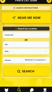
Yes, the app is intended to help users search for CAT Scale locations based on their current position or a selected area. Location access may be required for the most convenient experience, although you can generally search manually if you prefer not to share your position. Results can help identify nearby facilities, making it simpler to choose a scale without searching through unrelated map listings.
What information can I check about a CAT Scale location?
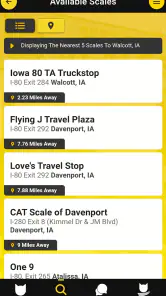
The available details may vary by location, but CAT Scale Locator can provide useful information such as the facility’s address, distance, contact details, and directions. Some locations may also display operating information or nearby services. Before relying on a listing, it is still wise to confirm hours and accessibility directly, since facility information can change after an app update.
Pros
- Quickly locates nearby CAT scales using your device’s current position.
- Useful for checking scale locations before starting a commercial trip.
- Helps reduce detours by showing facilities along or near your route.
- Simple interface makes searching practical for drivers on the road.
- Can support trip planning when weight checks are required.
Cons
- Coverage may vary by region
- especially outside major trucking routes.
- Location details can become outdated if facilities change hours or ownership.
- Requires location access for the most convenient nearby-scale searches.
- It may not provide live wait times
- closures
- or scale availability.
- Some listed locations may require extra verification before visiting.
- Category
- Maps & Navigation
- Version
- 7.1.3











