Beans - Maps for Apartments
- 564.00
- 2.1
- Installs
- 50.00K
- Price
- Free

Screenshots


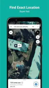
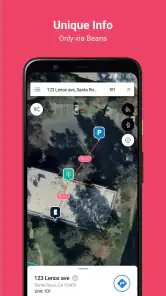
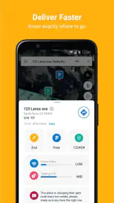
Analysis by Reviewed
I approached Beans - Maps for Apartments as a practical navigation tool rather than another general-purpose map. Its focus is apartment-related searching, delivery, parking, directions, and driving, which gives it a narrower purpose than the map app most people already keep on their phone. That focus is useful when the difficult part of a trip is not finding the street, but finding the correct building, entrance, or stopping point once you arrive.
My overall impression is mixed but fairly clear: this is an interesting idea for people who regularly visit apartment communities, yet it is not a universal replacement for a mainstream navigation service. The app is free to install, is intended for everyone, and comes from One Hundred Feet, Inc. Its current version is 5.4, and it runs on Android devices using version 6.0 or later. Those details make it accessible to many older phones, although the modest average rating of 2.1 from around 1.5 thousand ratings suggests that the experience has not worked smoothly for every user.
How Beans fits into an everyday trip
The best way to understand this app is to picture a delivery driver, service worker, visitor, or resident trying to reach a particular apartment rather than simply a street address. A normal map can guide you to a complex, but apartment communities often contain several buildings, internal roads, parking areas, gates, and entrances. A destination that looks simple on paper can become confusing after the main road disappears behind a large property entrance.
Beans is built around that kind of problem. Its apartment-oriented approach makes it more relevant when the final part of the journey matters as much as the route to the neighborhood. I found that distinction important because many navigation tools are excellent at long-distance routing and much less helpful with the last few minutes inside a residential development.
Imagine arriving at an apartment complex after dark with a grocery delivery. The street address may lead you to the property entrance, but you still need to identify the right building, decide where a vehicle can stop, and avoid circling the same internal lane. A specialized apartment map can be valuable in that moment because it encourages you to think about the property as a navigable place, not just a pin on a public road.
That does not mean every apartment address becomes effortless. The usefulness depends heavily on how well a particular property is represented and how current its layout is. I would treat the app as a focused aid for the final approach, not as permission to ignore signs, access rules, or the information supplied by a resident.
A focused alternative to familiar map apps
Compared with Google Maps, Apple Maps, or another broad navigation app, Beans has a smaller field of view and a more specific reason to exist. The usual alternatives are better choices when you need traffic context, public transit planning, business discovery, broad place search, or a dependable route across an entire city. They are also the safer first choice when you are driving somewhere unfamiliar and need a mature general navigation experience.
More From Our News Desk

Clash of Clans Is Won Between the Battles

Android Auto Makes the Case for Quieter Car Software

MobiOffice: Transforming Mobile Productivity with Seamless Integration

EA SPORTS FC™ Mobile Soccer: Redefining Mobile Sports Gaming

How Microsoft OneDrive Became a Mobile Productivity Giant

How Google Translate Breaks Language Barriers Effortlessly
Beans becomes more appealing when the destination is an apartment community and ordinary mapping leaves you with too much guesswork at the end. That is the central trade-off. You gain a property-focused perspective, but you should not expect the same breadth as a full mapping platform. I would use the two types of app together when the trip is important: a standard map for the main route, then Beans for apartment-specific orientation.
For a resident, the app may be most useful before sharing an address with a guest or delivery person. Checking how the location appears from a visitor’s point of view can reveal whether a building number, entrance, or parking area is likely to cause confusion. For a driver, it can support a repeatable workflow: review the property before leaving, identify the likely stopping area, and confirm the building after entering.
What the current version tells me
The current release is version 5.4, while the app first appeared on November 19, 2018. That history matters because this is not a brand-new experiment with no time to mature. It has had an opportunity to develop through multiple releases, and the version number indicates an established product rather than a first public build.
At the same time, a version number alone does not guarantee that every apartment layout, address detail, or navigation instruction is current. Property maps can become outdated when buildings are renamed, parking patterns change, entrances are closed, or construction alters internal roads. I would therefore verify the final approach visually and follow on-site signs even when the map appears confident.
For existing users, the practical question is less “what is the newest number?” and more “does the app behave consistently for the properties I visit?” If your regular apartment communities are represented accurately, the focused design may save time. If your area has incomplete or stale property information, the specialized purpose loses much of its advantage over a normal map.
Where the app can save time
One of the less obvious benefits of an apartment-focused map is preparation. You do not have to wait until you are already lost to use it. Before driving, I would inspect the destination, note the building relationship to the entrance, and decide whether the address appears to lead toward a resident parking area, visitor area, or another stopping point. That small planning step can prevent a late arrival from turning into a slow loop through the property.
Another useful workflow is to use it as a communication check. If a friend says, “I’m at the apartments,” that may not be enough information for a visitor. Looking at the property layout can help you ask a more precise question, such as which building or entrance they mean. This is especially useful for larger communities where multiple buildings share one postal address.
Delivery work is another natural use case, but it comes with an important limitation. A map can help you understand the layout; it cannot override a locked gate, a private road, a reserved parking rule, or a resident’s instructions. I would use the app to reduce uncertainty, then rely on the recipient’s directions when the property’s real-world conditions differ from the map.
For apartment hunting, I see a different advantage. A prospective renter can use the map perspective to think about how a building relates to entrances, driveways, and parking rather than judging the address only by its position on a city map. That does not replace an in-person visit, but it can make the first visit more efficient and help you formulate better questions.
Important friction before relying on it
The low average rating is the most visible warning sign. It does not tell me that the concept is worthless, but it does tell me to avoid treating the app as a guaranteed solution. A navigation tool is judged at stressful moments, and even a small mismatch between the map and the real property can create a frustrating experience.
I would also be cautious about using Beans as the only navigation tool for time-sensitive travel. If you are heading to an appointment, transporting someone, or driving in an unfamiliar area, a mainstream navigation app is likely to be the better primary choice because it is designed for broader route planning. Beans makes more sense as a specialist layer for apartment details.
There is also a learning curve created by its narrow purpose. Someone who only needs directions to a house or a storefront may not gain much from installing another map app. The benefit appears when apartment layouts repeatedly create problems. If that situation does not describe your routine, the extra app may add more steps than value.
Because the app includes in-app purchases priced at $4.99 per item, I would also pay attention to which parts of the experience are available without payment before building a daily workflow around it. The app itself is free, but “free to install” and “completely free for every useful function” are not necessarily the same thing. I would test the destinations that matter to me first and decide whether the optional purchases solve a real problem rather than buying automatically.
Who should install it
I can recommend trying Beans if you deliver to apartments, work in residential maintenance, visit multiple apartment communities each week, or live in a complex where guests regularly struggle with entrances and buildings. Those users have a repeated problem that a specialized map may address better than a general one.
It may also suit people who prefer to prepare before driving. The app’s value is not limited to active turn-by-turn use; reviewing a property in advance can make an unfamiliar destination feel less ambiguous. That preparation is particularly worthwhile when a missed entrance would require a long loop to return.
I would skip it if you mainly need citywide navigation, transit information, traffic-aware route planning, or business search. In those cases, the established map already on your phone is probably more efficient. I would also skip making it your sole tool if a wrong entrance could cause a serious delay. The apartment focus is useful, but it should complement common sense and, when necessary, another navigation service.
What I would watch in future updates
For future releases, I would care most about reliability at the property level. Clearer handling of changed entrances, building labels, parking areas, and internal roads would matter more to me than a cosmetic redesign. A specialized map earns trust when it reflects the details that general maps often flatten into one address pin.
I would also watch how the app balances specialist information with ordinary driving needs. The strongest version of Beans would remain focused on apartments without making users switch awkwardly between tools during the same trip. Smooth handoff to a general route, easy confirmation of the final building, and clear distinction between a mapped suggestion and an on-site rule would all improve confidence.
Existing users should judge updates by practical results rather than by the release number alone. After installing a new version, I would test a familiar apartment community and compare the route with what I already know. Then I would try one unfamiliar property where the final approach is usually difficult. That simple check reveals whether an update improves real navigation or merely changes the surface.
My final take on the apartment-focused approach
Beans - Maps for Apartments is a specialized tool with a sensible target: the confusing final stretch of apartment navigation. I like the idea because apartment communities are not always well described by a single street address, and a property-aware view can help residents, visitors, and delivery workers plan more intelligently.
Still, I would not present it as a replacement for the usual map apps. Its low user rating makes a cautious trial appropriate, and the quality of the experience may vary from one property to another. The free entry point makes testing easy, while the $4.99 in-app purchase price is something I would consider only after confirming that the app solves a recurring problem for me.
My recommendation is simple: install it if apartment entrances, buildings, or parking repeatedly slow you down, and use it alongside your normal navigation app at first. Test it on the properties you actually visit, keep an eye on real-world signs, and do not assume that a map can replace current instructions from a resident or property manager. Its strongest role is as a last-mile apartment guide, not as an all-purpose navigation replacement.
Beans - Maps for Apartments Frequently Asked Questions
Which apartment communities can I look up in Beans?
Beans is most useful when the apartment community you need is included in its property maps. Its focus is on apartment-level navigation rather than general turn-by-turn travel, so availability can depend on the community. Before relying on it for a visit or delivery, check whether the relevant property and the places you need to find appear in the app.
What should I know about Beans before downloading it?
Beans – Maps for Apartments is a free Maps & Navigation app from One Hundred Feet, Inc., focused on helping people navigate apartment communities. It is rated for Everyone, and its current version is 5.4. The app may suit residents, visitors, and delivery drivers, but its usefulness depends on whether a property is represented and on the map details available there.
What is Beans – Maps for Apartments used for?
Beans – Maps for Apartments is designed to help users navigate large apartment communities and find individual buildings, entrances, parking areas, amenities, and other important locations. Instead of relying only on a standard street map, the app focuses on property-level details that can be difficult to identify in everyday navigation, especially when visiting an unfamiliar complex or meeting someone at a specific unit.
Can Beans help me locate a specific apartment or building?
Yes, the app is intended to make apartment-community navigation easier by displaying maps and location details for participating properties. Depending on the community and the information available, you may be able to search for a building, unit, entrance, parking area, mailbox, leasing office, or amenity. Coverage and accuracy can vary, so users should still check the property’s instructions when precise access information is important.
Does Beans – Maps for Apartments require location access?
Location access is generally useful because it allows the app to show your position within or near an apartment community and provide more relevant navigation guidance. You may be able to browse some maps without sharing your location, but certain navigation features can be limited. For privacy, review the permission request carefully and choose the device setting that matches how you plan to use the app.
Pros
- Focused apartment search makes browsing rental listings quick and straightforward.
- Map-based results help compare neighborhoods and nearby locations at a glance.
- Useful filters can narrow listings by price
- size
- and other key preferences.
- Clean interface is approachable for users unfamiliar with property-search apps.
- Saved listings make it easier to revisit apartments that match your criteria.
Cons
- Listing availability may vary depending on the city or region you are searching.
- Some apartments may have limited photos or incomplete property information.
- Highly competitive listings can disappear before you have time to contact the owner.
- Map browsing may use extra battery and mobile data during extended searches.
- Users may need another service to verify landlords
- fees
- and listing authenticity.
- Category
- Maps & Navigation
- Version
- 5.4











