ATAK-CIV (Civil Use)
- 289.00
- 3.7
- Installs
- 500.00K
- Price
- Free

Screenshots
Analysis by Reviewed
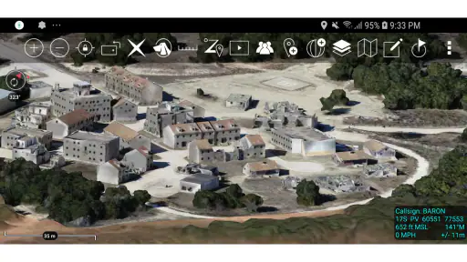
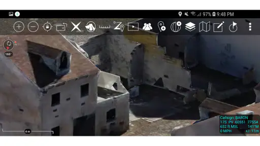
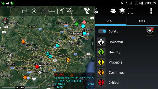
ATAK-CIV is the kind of navigation app that makes a strong first impression because it asks you to think about maps differently. Instead of treating a map as a simple picture with a blue dot, it presents itself as a geospatial and situational-awareness tool for Android. I found the appeal easy to understand: it is built for people who want more context around a location, a route, or an unfolding situation, rather than only turn-by-turn directions.
That focus also makes it very different from the navigation apps most people open every day. The developer, TAK Product Center, has created something that feels closer to a field-oriented mapping workspace than a conventional driving companion. It is free, which removes the biggest barrier to trying it, but the real question is whether it earns a permanent place on your phone after the initial curiosity wears off.
My short answer is that it can, but only for a particular kind of user. If you enjoy working with detailed maps, planning outdoor movement, monitoring changing conditions, or keeping geographic information organized, ATAK-CIV has lasting potential. If you simply need the fastest route to a shop or a voice guiding you through city traffic, the usual mainstream alternative will feel easier and more polished.
What the first week feels like
The first week with ATAK-CIV is mostly about learning its way of thinking. A normal map application tends to hide complexity until you need it. This app puts the map at the center and expects you to interact with geographic information deliberately. That can feel refreshing when you want control, but it also means the opening experience is less immediate than dropping a destination into a familiar navigation app.
I would not judge it after a single launch. The interface makes more sense when you give yourself a practical task, such as examining an unfamiliar area, preparing a route for an outdoor trip, or organizing points that matter to a group. Without a real use case, the number of mapping possibilities can feel like work. With one, the app becomes much easier to understand because every tool has a reason to exist.
One of the most useful early habits is to treat the display as a working map rather than a passive reference. I found myself looking at it in layers of attention: first the general area, then the route or points that mattered, and finally the surrounding details that could affect a decision. That approach is more valuable than simply zooming in and out aimlessly. It also reveals why the app is aimed at situational awareness instead of ordinary commuting.
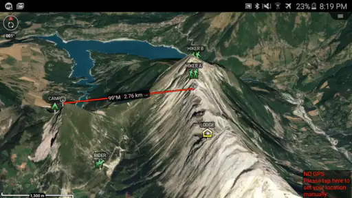
A realistic everyday example would be a weekend hike with several friends. Before leaving, I could use the app to study the area, mark meaningful locations, and keep the group focused on the same geographic picture. During the outing, the value would not come from the app cheerfully announcing every turn. It would come from having a shared reference for where the group is, what lies around it, and which points deserve attention. That is a different kind of help, and it is the reason ATAK-CIV may appeal to experienced outdoor users.
More From Our News Desk

Clash of Clans Is Won Between the Battles

Android Auto Makes the Case for Quieter Car Software

MobiOffice: Transforming Mobile Productivity with Seamless Integration

EA SPORTS FC™ Mobile Soccer: Redefining Mobile Sports Gaming

How Microsoft OneDrive Became a Mobile Productivity Giant

How Google Translate Breaks Language Barriers Effortlessly
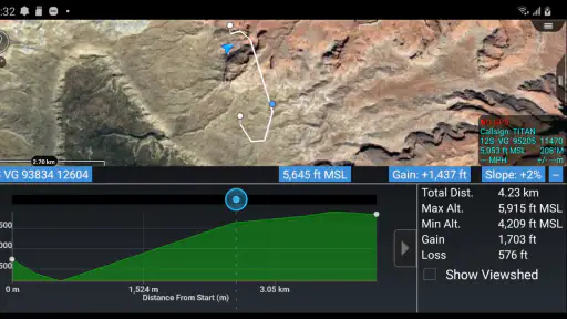
The first-week learning curve is the main price of admission. People who already understand map reading, coordinates, routes, and field planning will probably settle in faster. Beginners may need patience before the screen feels useful rather than busy. I recommend starting with one small project instead of trying to understand every capability at once. Build familiarity around a single area, then expand your workflow only when you have a clear reason.
The app is available at no cost, and its Android compatibility reaches back to Android 5.0. That makes trying it straightforward on a wide range of devices. Its content rating is Teen, so it should not be approached as a child-focused map toy. I also appreciate that the free entry point lets curious users test whether this specialized style of navigation fits them before committing time to a deeper setup.
Where it beats an ordinary map
The biggest difference from Google Maps, Apple Maps, or similar everyday services is the purpose of the screen. Those alternatives are excellent when the destination is known and the main problem is getting there efficiently. ATAK-CIV is more interesting when the problem is understanding an area, coordinating movement, or keeping track of geographic information that does not fit neatly into a simple destination search.
That distinction matters in situations where the route is only one part of the decision. An outdoor group may care about meeting points, alternate approaches, access concerns, and the relationship between several locations. A volunteer team may need a common picture of an affected area. A serious map hobbyist may simply want a more active role in examining the terrain and organizing information. In each case, the app’s value comes from context rather than convenience alone.
My first non-obvious tip is to use it as a planning discipline. Before opening the app, write down the question you want the map to answer: where should we meet, which approach is safer, what locations must the group recognize, or how do several points relate to one another? That simple step prevents the map from becoming an endless browsing session. ATAK-CIV is much more effective when every mark or view supports a decision.
My second tip is to separate preparation from live use. A phone screen is a poor place to invent a plan while everyone is waiting. I would prepare the geographic picture in advance, review it calmly, and then use the app in the field for reference and updates. This reduces distraction and makes the application feel like a tool rather than another source of screen time.
The point where novelty becomes routine
After the first week, the app’s value depends on repetition. A specialized map tool does not automatically become a habit just because it has many capabilities. I kept returning to the question of whether it solved a recurring problem or merely offered an interesting display. For me, the answer was positive only when I connected it to specific activities that benefit from geographic awareness.
Outdoor planning is the clearest recurring use. If you regularly hike, volunteer in the field, explore unfamiliar places, or coordinate a small group, the app can become part of your preparation routine. It gives you a reason to revisit locations, refine your understanding, and keep important information in one working environment. That repeated cycle is what turns a technically impressive app into a useful one.
For an occasional traveler who only needs directions between familiar businesses, the pattern is different. The app may be interesting for a few sessions, but it is unlikely to replace a simpler navigation service. Mainstream alternatives reduce the number of decisions required, provide a more familiar search experience, and are generally better suited to quick urban trips. Choosing ATAK-CIV for that job would be like bringing a detailed planning board to a task that needs a simple signpost.
The current version is 5.6.0.12 (9c9a5897)[playstore], and the app has been available since September 1, 2020. I mention the version because specialized tools benefit from being kept current, especially when users depend on them for planning rather than casual browsing. The practical lesson is not to install it once and forget it. Check that the version on your device remains current before an important trip, and give yourself time to become familiar with any changes.
Its audience size suggests that this is not an obscure experiment. ATAK-CIV has passed half a million installs, while its average rating sits at 3.7 from around 1.7 thousand ratings. I read that combination as a useful warning rather than a verdict. Enough people have tried it to establish a real user base, but the rating also reflects the fact that specialized mapping tools can frustrate people who expect the smoothness of a mainstream navigation app.
Keeping it useful without creating extra work
The maintenance burden is part of the product
The lasting value of ATAK-CIV depends on maintenance more than many ordinary apps do. A simple map search can be forgotten between trips without much consequence. A situational-awareness workflow is different: if your saved information, planned routes, or shared conventions become messy, the app gradually loses trust. The cost is not only technical upkeep; it is the attention needed to keep your geographic workspace understandable.
I recommend a small, strict routine. Keep names consistent, remove points that no longer matter, and review an area before relying on it. Avoid creating a separate marker for every passing thought. A crowded map may look informative, but it can make the important information harder to recognize. The best long-term setup is usually the one that shows less, but shows the right things clearly.
A third concrete insight is to create a “minimum useful map” for each activity. For a hike, that might mean only the route, meeting location, key reference points, and alternatives. For a volunteer task, it might mean the operational area and the locations the team must recognize. This approach reduces visual fatigue and makes it easier for another person to understand your plan without a long explanation.
Because the app is intended for situational awareness, I would also avoid treating the phone as the only source of judgment. A map can organize information, but it cannot replace local knowledge, changing conditions, common sense, or a backup plan. That is especially important outdoors, where a screen may become inconvenient at exactly the moment when attention should move to the surroundings. ATAK-CIV works best as an aid to decisions, not as permission to stop making them.
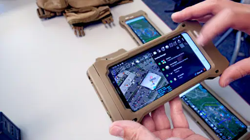
New users may reasonably wonder whether they need special equipment or professional experience. My view is that neither is necessary to explore the app, but experience with maps will make the process far more comfortable. The application is not limited to one narrow profession, yet its design rewards people who already think in terms of locations, routes, groups, and changing circumstances. A casual user can learn it, but should expect to invest time rather than receive instant simplicity.
Where fatigue starts to appear
The same depth that makes ATAK-CIV interesting can become tiring. There is a mental difference between checking a destination and managing a geographic workspace. If I open the app for a quick answer, I may spend more time orienting myself than I would with a conventional navigation service. That is not necessarily poor design; it is a consequence of serving a more demanding purpose.
Another source of fatigue is the temptation to over-plan. Detailed mapping encourages detailed thinking, which is useful until preparation becomes an end in itself. I found it important to decide when the map had answered the question and close the app. Otherwise, the process can drift from practical planning into endless adjustment.
Group use can also create friction if everyone interprets the map differently. Before sharing a plan, agree on names, meeting points, and what the symbols or markings mean to your group. The app can support a common geographic picture, but it cannot automatically create common understanding. A five-minute conversation before setting out may be more valuable than another round of map editing.
Privacy and attention deserve practical consideration as well. Any app that helps you organize locations can encourage you to keep more geographic information than you really need. I would review what remains on the device after a project ends and avoid collecting sensitive location details without a clear reason. I would also use the app deliberately in public or unfamiliar places rather than staring at the screen continuously.
People often ask whether it can replace regular navigation. In my experience, it should not be viewed as a universal replacement. Keep a conventional navigation app for quick destination searches and city driving, then use ATAK-CIV when the task calls for a broader operational picture. The two approaches solve different problems, and forcing one to do the other’s job usually creates frustration.
Who will keep opening it after the first month?
The strongest candidates are people with recurring geographic projects. Hikers who plan their own routes, outdoor clubs, volunteer coordinators, map enthusiasts, and users who need to discuss movement around an area can all find a reason to return. For these users, the app becomes valuable because each session builds on the previous one. Familiarity reduces the initial friction, while the map retains practical relevance.
It is also a good fit for someone who dislikes the limitations of a destination-first interface. If you prefer examining an area before deciding where to go, or if your plans involve several locations rather than one address, ATAK-CIV offers a more natural way to think. That freedom comes with responsibility: you must organize the information and decide what matters.
I would advise skipping it if your main needs are restaurant searches, traffic-aware commuting, public-transit directions, or effortless turn-by-turn driving. You may be able to use it for pieces of those tasks, but the experience is not optimized around the convenience that makes mainstream map apps so popular. It is also a poor choice if you are unwilling to learn a specialized interface or maintain your map information between outings.
The app’s Teen content rating is another reason to think about audience and context. It is not presented as a playful family navigation product, and younger users should approach it with appropriate supervision and a clear purpose. For adults, the rating is less important than the mindset it signals: this is a serious mapping tool, not merely a colorful way to find nearby places.
My long-term verdict
After the novelty fades, ATAK-CIV earns space on an Android phone only when it is attached to a repeatable habit. Its best qualities are not the ones that impress for five minutes; they are the ability to support deliberate geographic planning, keep a group focused on the same area, and encourage a richer understanding of movement and place. Those benefits become clearer with use rather than immediately.
I like that it is free to try and that it serves a purpose ordinary navigation apps generally do not prioritize. I also respect the trade-off: the user must bring patience, map literacy, and some organizational discipline. The app will not magically turn a vague plan into a reliable one. It gives you a stronger workspace, but you still have to decide what belongs there and how to use it responsibly.
My final recommendation is simple. Install it if you regularly plan outdoor activity, coordinate people around locations, or want a serious situational-awareness map on Android. Start with one concrete project, keep the map uncluttered, and build a small maintenance routine. If your needs are limited to fast directions and nearby-place searches, choose the familiar alternative instead and save yourself the learning curve.
ATAK-CIV is worth keeping when geographic awareness is a recurring task, not merely a passing curiosity. For the right user, that makes it more than another map app: it becomes a dependable planning habit. For everyone else, its depth may feel like unnecessary effort, and recognizing that early is part of making the right choice.
ATAK-CIV (Civil Use) Frequently Asked Questions
Is ATAK-CIV available for iPhone, or is it an Android app?
ATAK-CIV is an Android application, so iPhone users should not expect to install this version on iOS. Its mapping and team-awareness tools are designed for use on Android devices. If your group relies on ATAK-CIV, check that each person has a compatible Android device and that everyone uses compatible communication services and configurations before planning to work together.
Is ATAK-CIV free, and what Android version does it support?
ATAK-CIV is free to download and is intended for Android devices running Android 5.0 or later. It is rated Teen, so families should consider that rating when deciding whether it is appropriate for a younger user. The app is developed by TAK Product Center and is listed in Maps & Navigation, reflecting its focus on mapping and situational awareness rather than everyday turn-by-turn driving alone.
What is ATAK-CIV (Civil Use), and what is it designed for?
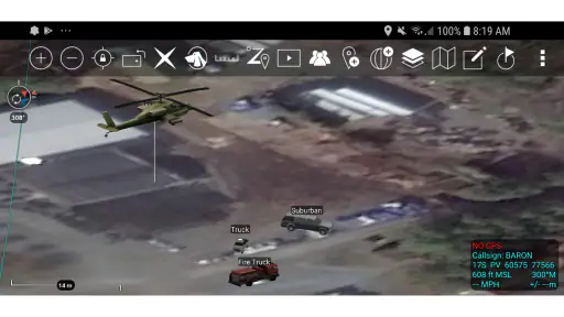
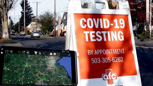
ATAK-CIV, short for Android Team Awareness Kit–Civil Use, is a situational-awareness and mapping application for Android devices. It helps users view maps, mark locations, share positions, plan routes, exchange messages, and coordinate teams in the field. It is commonly used for search and rescue, disaster response, outdoor operations, public safety, and other activities where accurate location information is important.
Does ATAK-CIV require an internet connection to work?
ATAK-CIV can operate both online and offline, but its capabilities depend on the maps, data, and plugins installed on the device. Before going into an area with limited coverage, users should download suitable map packages and verify that they are available offline. Internet or another communication network may still be necessary for live position sharing, messaging, weather information, map updates, or collaboration with other team members.
Is ATAK-CIV suitable for beginners, or is it mainly for trained users?
The application offers powerful tools, but it is more complex than a typical navigation app. New users may need time to understand layers, markers, routes, overlays, communication settings, and plugin-based features. It is best suited to users who are willing to learn the interface and practice before relying on it in a real operation. Teams should also establish common procedures for sharing locations and information.
Pros
- Powerful offline mapping and navigation capabilities
- Supports detailed topographic and satellite map layers
- Offers location sharing and team coordination tools
- Highly customizable with plugins and data overlays
- Useful for emergency response and outdoor operations
Cons
- Steep learning curve for first-time users
- Interface can feel crowded on smaller phone screens
- Some map sources require separate downloads or setup
- Advanced features may need technical configuration
- Can consume significant battery during continuous GPS use
- Category
- Maps & Navigation
- Version
- 5.6.0.12 (9c9a5897)[playstore]











