CrimeRadar: Dispatch Alerts
- 5.31K
- 4.8
- Installs
- 1.00M
- Price
- Free

Screenshots
Analysis by Reviewed
I approached CrimeRadar: Dispatch Alerts as a practical news and safety app rather than something to browse casually. Its purpose is to help me keep an eye on nearby activity through a map and alerts connected to live first-responder radio. That makes it potentially useful when I want context about what is happening around my neighborhood, on a commute, or near a place I am about to visit. It also means the app needs to be judged carefully: information that feels immediate is not automatically complete, precise, or suitable for making urgent decisions.
Developed by Scoopz LLC, this free News & Magazines app is available to a broad audience with an Everyone content rating. It has attracted more than a million installs, and its average rating sits at 4.8 from roughly 38 thousand ratings, with about 5.3 thousand written reviews. Those figures suggest that the basic idea connects with many people, but my experience is that its usefulness depends heavily on how comfortably you can read a busy map, interpret alerts, and stay calm when radio activity sounds serious.
How CrimeRadar works for different users and situations
Readability and navigation: useful information, but not a passive news feed
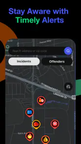
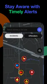
The map is the center of the experience. Instead of opening to a conventional list of headlines, I am encouraged to think geographically: what is happening near me, and how does that relate to where I am going? That is a meaningful difference from general news apps, which usually organize information by topic, publication, or time. Here, location is the organizing principle, so the app makes more sense when I have a specific area in mind.
I found that this approach can be helpful for people who understand information faster when it is tied to a familiar place. A map can turn an abstract report into something easier to interpret: an event is not merely “somewhere nearby,” but in relation to a route, a neighborhood, or a public place. At the same time, maps can become visually demanding. Several markers, changing alerts, and surrounding labels may require more attention than a simple text list.
For a reader with low vision, the most important practical question is not whether the app is interesting, but whether the map and alert text can be enlarged or read comfortably through the phone’s own display and accessibility settings. I would test that immediately after installation rather than assuming the interface will adapt perfectly. The current version is 26.33.1, and the app supports Android 8.0 or later, so compatibility with an older device may be a consideration for anyone relying on a particular handset or display setup.
I also recommend using the map deliberately instead of repeatedly zooming and panning without a goal. First identify the area that matters, then inspect the surrounding alerts one at a time. This reduces visual clutter and makes it less likely that I will confuse a nearby incident with one that is actually relevant to my route. That simple habit is one of the more useful ways to make the interface manageable for people who find dense screens tiring.
The app is easier to understand when I treat it as a situational overview, not a complete local-news archive. A general news application may provide more background, official statements, and follow-up reporting. CrimeRadar’s value is the rapid geographic view. If I need a full explanation of an event, I would use this app as an early signal and then look for a reliable source with more context.
More From Our News Desk

Clash of Clans Is Won Between the Battles

Android Auto Makes the Case for Quieter Car Software

MobiOffice: Transforming Mobile Productivity with Seamless Integration

EA SPORTS FC™ Mobile Soccer: Redefining Mobile Sports Gaming

How Microsoft OneDrive Became a Mobile Productivity Giant

How Google Translate Breaks Language Barriers Effortlessly
Motor and sensory considerations: reducing effort matters
Apps built around maps and live alerts can create extra physical effort. I may need to tap small map elements, drag the view, zoom repeatedly, or react to notifications while walking or carrying something. That does not make the app unusable, but it changes how I would recommend using it. For someone with limited dexterity, the best experience is likely to come from checking it while stationary, with the phone supported, rather than trying to operate it during a hurried journey.
A useful routine is to prepare the view before leaving: open the area of interest, check the visible alerts, and avoid making the app part of a multitasking routine that requires constant interaction. This is especially relevant for older users or anyone who experiences hand fatigue. A map that seems simple during a quiet test can feel much harder when I am moving, wearing gloves, or dealing with poor weather.
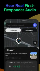
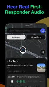
The live first-responder radio element also raises sensory considerations. Audio can provide information without requiring constant reading, but radio communication may be difficult to follow for people who are deaf or hard of hearing, for users who process spoken language slowly, or in places with heavy background noise. In those situations, the visual alert and map side of the app becomes more important. I would not assume that hearing the radio is necessary for every part of the experience, but I would also not rely on audio alone when an alert matters.
On the other hand, users who are sensitive to sudden sound may prefer to keep the phone quiet and inspect information visually. A safety-oriented app should not encourage me to leave audio running continuously if that makes concentration harder. I would choose a notification approach that fits my environment and use the map when I am ready to interpret it. This is a small but important distinction: accessibility is not only about adding information, but also about avoiding an overload of competing signals.
People with reading difficulties may benefit from taking one alert at a time and translating it into a simple personal question: is this near me, does it affect my route, and do I need to change what I am doing? That workflow is better than trying to absorb every item on the screen. It also prevents a common mistake with live information: treating the volume of activity as a direct measure of personal danger.
Situational access: where the app fits into everyday life
My most realistic use case is an evening trip home. I might check the map before leaving work, notice activity around a transfer point, and decide whether I want to take a different route or wait before heading out. In that situation, the app gives me a quick local snapshot. It does not replace judgment, public safety instructions, or emergency services, but it can help me decide whether I should gather more information before continuing.
Another use is checking an area before visiting it for the first time. A parent, caregiver, delivery worker, or person returning home late may appreciate a location-based view more than a stream of unrelated national headlines. The benefit is strongest when the question is narrow: “What is happening around this place right now?” The benefit is weaker when I want a calm, verified account of what happened earlier in the day.
For people with cognitive disabilities or anxiety, the app can be helpful only if used with boundaries. Live alerts may provide reassurance by making an unfamiliar area feel more understandable, but they can also encourage repeated checking. I would set a personal rule: check before a trip or when there is a concrete reason, then close the app. Constant monitoring can turn useful awareness into stress, especially when radio activity is hard to interpret without official context.
The same principle applies to teenagers and families. The Everyone rating makes the app broadly accessible from an age-classification perspective, but an age rating does not teach a young user how to interpret emergency-related information. I would show a child how to distinguish an alert from a confirmed conclusion and explain that a marker does not automatically mean the surrounding area is unsafe. That conversation is more important than simply installing the app.
It is also worth thinking about privacy and attention in public. Looking down at a phone while walking can create a different safety problem. I would check the app before moving, not while crossing streets or navigating unfamiliar ground. For users with mobility limitations, this may mean asking a companion to inspect the map or using the app during a planned pause rather than while negotiating a crowded sidewalk.
What the app does well compared with ordinary alternatives
Compared with a standard news app, CrimeRadar is more immediate in a geographic sense. A newspaper-style feed may offer better writing and more complete explanations, but I usually have to search for local information myself. Here, the map gives me a starting point without requiring me to know which outlet reported an event. That is the app’s clearest strength.
Compared with manually listening to public-safety radio, the app is more approachable for someone who wants a visual reference. I can connect activity with a place instead of trying to remember every spoken location. However, radio-based information can still be fragmented, and a visual map cannot turn an incomplete transmission into a confirmed report. The app is therefore best for awareness and orientation, not for making claims about what definitely happened.
Compared with official emergency channels, it should not be my only source during a serious incident. Official instructions have priority because they are intended to guide public action. CrimeRadar can help me notice that something may be developing, but it is not a substitute for emergency services, evacuation directions, or direct communication from local authorities.
Compared with neighborhood social networks, the app may feel less conversational and less dependent on personal reports. That can be an advantage when I want a focused safety view rather than speculation. The trade-off is that I may receive less human context, fewer explanations, and less help understanding the wider situation. I would use the two kinds of tools differently instead of expecting one to replace the other.
Remaining barriers and practical compromises
The biggest barrier is interpretation. A live alert can feel authoritative simply because it appears quickly, yet speed does not tell me whether the event is resolved, whether the location is exact, or whether it affects ordinary travel. I have to resist turning a notification into a conclusion. This is especially important for users who process information literally or who may find ambiguous alerts distressing.
Another barrier is the map itself. Location-based interfaces are not equally comfortable for everyone, particularly users with low vision, dyslexia, attention difficulties, or limited experience with digital maps. I would prefer a clear text-based way to review the same information, but I would not assume that every visual interaction has an equally convenient alternative. Anyone who depends on a screen reader, magnification, switch access, or voice control should test the core tasks directly: opening an alert, understanding its location, and returning to the main view.
There is also a financial detail that is easy to overlook. The app is free to download, but in-app purchases range from five cents to nearly eighty dollars per item. That does not automatically make the free experience poor, but I would review any purchase prompt carefully and avoid assuming that every useful capability is included without charge. Families sharing a device should be particularly cautious about accidental purchases.
Notifications can create another form of friction. Alerts are valuable only when they reach me in a form I can notice and understand, but too many interruptions can make me ignore the next one. I would begin with a limited notification setup, observe whether it helps or distracts me, and adjust my routine accordingly. For someone who is hard of hearing, a visual checking habit may be more dependable than expecting an audio cue. For someone sensitive to interruptions, opening the app at selected times may be the better compromise.
Finally, the app may not suit people who want certainty, long-form reporting, or a quiet reading experience. Its live, location-focused character is precisely what makes it useful for some situations and unsuitable for others. If my main goal is understanding causes, legal developments, community impact, or official follow-up, I would choose a traditional news source and use this app only as a supplementary awareness tool.
Who should use it, and who should skip it?
I would recommend CrimeRadar to adults who want a quick way to scan activity around a specific area and who are comfortable checking information critically. It is particularly appealing to commuters, people visiting unfamiliar neighborhoods, caregivers planning routes, and anyone who prefers a map to a scrolling list. The free price makes it easy to try, while the strong user response—an average of 4.8 across roughly 38 thousand ratings—shows that the concept has found a substantial audience.
I would be more cautious recommending it to someone who becomes anxious when exposed to live incident information, someone who needs highly detailed official explanations, or someone who cannot comfortably operate a map interface. It may also be a poor fit for users who need guaranteed, immediately actionable accessibility support and do not have time to test the app with their own assistive setup. In those cases, official local channels or a simpler text-based news source may be more dependable.
My practical advice is to start with one familiar location, learn how the map presents an alert, and compare what you see with an official source before relying on it for decisions. Do not test it for the first time during an emergency. Establish a calm routine while the stakes are low, and decide in advance what would make you change plans and what would merely prompt you to seek more information.
An inclusive verdict on the everyday experience
CrimeRadar: Dispatch Alerts is a focused tool with a clear purpose: it places local safety-related activity on a map and connects that view with live first-responder radio. I like it most as an early-awareness layer, especially when I need to understand what is happening around a particular place rather than read general news. Its strongest advantage is speed and location; its main weakness is that I still have to interpret incomplete, potentially stressful information without confusing it with official confirmation.
From an inclusion standpoint, the app can work well for people who prefer visual geography, short checks, and location-based context. It requires more care for users with visual, hearing, motor, cognitive, or sensory needs because the experience may involve map navigation, spoken information, changing alerts, and attention-heavy decisions. Testing the core workflow with personal accessibility settings is essential.
Overall, I see it as a useful companion rather than a complete safety system. I would keep it for route awareness and local context, while turning to official channels for instructions and established news sources for explanation. If that division of roles suits the way you process information, the app is worth trying. If you need certainty, minimal stimulation, or effortless text-first navigation, another option may serve you better. Its free entry point is attractive, but I would remain aware of the in-app purchase range and make accessibility part of the decision from the first session.
CrimeRadar: Dispatch Alerts Frequently Asked Questions
What should I check before enabling CrimeRadar: Dispatch Alerts notifications?
Before enabling notifications, consider whether frequent safety updates will be useful in your daily routine and review the app’s notification and location permissions. Alerts can draw attention to nearby activity, but they may not provide complete context or arrive at the same time as an incident. Use them for general awareness, and rely on official channels for urgent instructions.
Can I choose which areas or types of alerts I see in CrimeRadar: Dispatch Alerts?
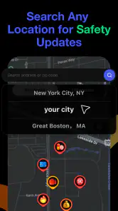
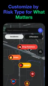
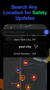
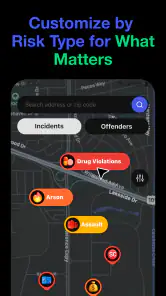
The app is designed around a safety map and dispatch-based alerts, so the location you select affects what information is relevant to you. Available incident details and coverage can differ by area. Explore the app’s settings and map after installation to see which choices are available, and avoid assuming that every location or incident type will be represented in the same way.
Is CrimeRadar: Dispatch Alerts free to download, and are there in-app purchases?
CrimeRadar: Dispatch Alerts is free to download, so you can try its safety map and dispatch-based alerts without an upfront purchase. The app also offers in-app purchases, with items ranging from five cents to just under eighty dollars. Check the purchase details in the app before confirming anything, especially if you plan to let someone else use your device.
Who makes CrimeRadar: Dispatch Alerts, and what should I know before installing it?
CrimeRadar: Dispatch Alerts is made by Scoopz LLC and is listed in the News & Magazines category. It is rated for Everyone and has an average rating of 4.8 from around 38,000 ratings. Those details can help set expectations, but the app’s usefulness will still depend on whether its dispatch information covers the places you care about and how you choose to use its alerts.
What is CrimeRadar: Dispatch Alerts, and what does it do?
CrimeRadar: Dispatch Alerts is a location-based public-safety app designed to provide information about reported incidents and emergency dispatch activity in selected areas. After choosing a location, users can review available alerts, incident categories, timestamps, and related details. It is intended to help users stay informed about nearby activity, not to replace official emergency services or verified police communication.
Pros
- Real-time alerts help users stay informed about nearby reported incidents.
- Location-based updates make it easier to monitor areas that matter to you.
- Useful for improving personal awareness during commutes or daily routines.
- Simple alert-focused design makes important information quick to find.
- Can help families discuss safer routes and local safety concerns.
Cons
- Alert accuracy depends on the quality and speed of local incident reports.
- Frequent notifications may become distracting in areas with many incidents.
- Coverage and usefulness can vary significantly between cities and regions.
- Reported crimes may cause unnecessary anxiety without additional context.
- Location permissions may raise privacy concerns for some users.

- Category
- News & Magazines
- Version
- 26.33.1