Passio GO!
- 573.00
- 4.3
- Installs
- 100.00K
- Price
- Free

Screenshots
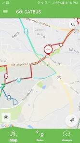
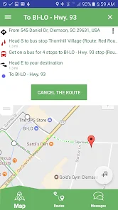
Analysis by Reviewed
If you’re looking for a way to check public transit vehicles and make a less uncertain journey, Passio GO! is worth understanding before you rely on it. I’d treat it as a transit companion rather than a general navigation or fitness app: its value is tied to the transit information available for the service you use. That distinction matters, because a real-time map is only useful when it covers your local network and its updates are current.
Using Passio GO! in everyday transit
Passio Technologies Inc developed this free Auto & Vehicles app, which is rated for Everyone and has an average rating of 4.3 from around 1,300 ratings. It has passed 100,000 installs, and its current version is 144. Those figures make it a familiar option for many riders, but they don’t guarantee that every route or vehicle in your area will appear. I would first check whether the transit service you need is represented before making it part of a time-sensitive routine.
Where riders can get stuck
The most common point of confusion with a transit locator is interpreting what appears on the map. A vehicle marker can help answer “where is my ride now?” but it is not, by itself, a promise that the vehicle will reach a stop at an exact time. I’d use the display as a live clue, then allow for the normal uncertainty of traffic, service changes, and the gap between a map update and what is happening on the road.
That makes the app especially useful when I already know my route and want to decide whether to leave now or wait a little longer. It is less helpful if I need a complete trip plan across services that the app does not cover. In that case, I’d compare it with the transit agency’s own information or a broader journey planner rather than assume one map tells the whole story.
Setup checks before relying on it
I’d start by confirming that the right transit system is available in the app, then make sure the phone has a working internet connection. If location-based information is relevant to the way I’m using it, I’d also check the phone’s location setting rather than repeatedly reopening the app and expecting a different result. These are simple checks, but they help separate a setup issue from a service or coverage limitation.
For a first trip, I’d look up the route while I still have time to choose another option. That small habit is more useful than testing the app for the first time at a stop when a vehicle is already due. Passio GO! is free, so trying it alongside the transit provider’s usual information is an easy way to judge whether its view suits my commute.
Recovering a workflow when information looks wrong
If the display seems stale or a vehicle is missing, I wouldn’t immediately assume the whole app has failed. I’d check connectivity, give the map a moment, and compare what I see with the agency’s own service notices or another reliable source. If the mismatch continues, switching to that backup is more sensible than waiting on a screen that may not reflect a disruption.
A useful routine is to check the app before leaving, then use it again near the stop only as one part of the decision. This reduces the temptation to watch the map continuously and gives me a clear fallback if the information changes. The app’s usefulness depends on both local coverage and timely transit updates, so having a second source matters most when arriving late would have real consequences.
When the app is not the cause
Transit delays, detours, weak connectivity, and information that has not caught up with events can all make a locator look unreliable. I’d distinguish between a problem that follows me across trips and a one-off mismatch on a disrupted service. If only one route looks unusual, checking the transit operator’s announcements is a better next step than reinstalling immediately.
Compared with a paper timetable, a live vehicle view can make waiting less of a guess. Compared with a general maps app, a transit-focused locator may be more convenient for checking vehicles, while a broader planner can be better for comparing modes or building a multi-part journey. I would use whichever source answers the actual question in front of me, and keep a backup for unfamiliar trips.
Who will get the most from it
I can see Passio GO! fitting a regular rider who knows their stops but wants a better sense of vehicle progress, especially when deciding when to head out. For example, on a rainy morning I might check the route before leaving home, then use the map to judge whether I can wait indoors a little longer. A visitor who needs step-by-step directions across several transit operators may be better served by a journey planner with wider coverage.
One practical trade-off is that live information encourages frequent checking, even when the service itself is the source of uncertainty. I’d use the map to make a decision, not treat every movement as a precise countdown. If your local network is supported and you mainly want a real-time look at transit, the app has a clear role; if coverage is limited or you need full trip planning, another tool should lead.
Making the app useful without watching it constantly
I’d build a simple routine around decisions rather than screen time: check the route before setting off, then check again when the next choice actually matters. That might mean deciding whether to leave the house, whether to walk to another stop, or whether to switch to a backup plan. This approach keeps the live map useful without turning every small movement into a reason to refresh it.
There is also a practical difference between checking a familiar commute and using the app for a first-time journey. On a route I know, a vehicle’s position can add context to my usual expectations. On an unfamiliar route, I still need to establish which stop and direction are right, and I would not rely on a vehicle marker alone to work out the full journey. For that, I’d keep a route planner or the operator’s own guidance open as a companion.
What to try when the first view is confusing
If I open the app and cannot immediately tell whether the map is showing the service I need, I’d pause before assuming the route is absent. I’d check the available transit system and make sure I have selected the intended area or service, where those choices are presented. Then I’d compare the result with information from the operator. A quick cross-check can reveal whether I’m looking at the wrong service or whether the issue is with current coverage or updates.
For someone helping a family member or a less confident phone user, I’d set up the first check together before a trip rather than explain it while they are rushing to a stop. Agree on a clear fallback, such as checking the operator’s notices or using a familiar timetable. That small bit of preparation matters more than learning every screen: it prevents a confusing map from becoming the only source of information at a stressful moment.
Choosing between a locator and a journey planner
Passio GO! makes the most sense when the immediate question is about transit vehicles and their progress. A general maps app can be more useful when I need to compare walking, driving, and transit, while an operator’s own service information can be the better reference for disruption notices. These tools answer different questions, so I wouldn’t judge the locator by whether it replaces all of them.
The trade-off is convenience versus breadth. Keeping a transit locator handy can make it quicker to check a known route, but switching between sources takes extra attention when a trip involves unfamiliar transfers or more than one operator. Before a complicated outing, I’d plan the overall journey elsewhere and use the live view only for the part it can help me judge.
First impressions and usability
From the moment I opened the app, I was greeted with a sleek and intuitive interface. No unnecessary clutter, just the essentials laid out in a user-friendly manner. The navigation is smooth, and I didn’t find myself getting lost or confused at any point. The team behind Passio GO! clearly put a lot of thought into making the user experience as seamless as possible.
Features that stand out
One of the standout features of this app is its real-time tracking capability. Whether you're walking, running, or cycling, Passio GO! tracks your every move with impressive accuracy. It’s like having a personal coach in your pocket. The app also offers a variety of workout plans tailored to different fitness levels, which is perfect if you’re just starting or looking to up your game.
Another feature I absolutely loved is the community aspect. You can connect with friends, share your progress, and even join challenges. It adds a layer of motivation that's hard to find in many fitness apps. Plus, being able to see how your pals are doing can really push you to go that extra mile!
Performance and reliability
In terms of performance, I didn’t encounter any glitches or crashes during my time with the app. It runs smoothly, and the data syncs up quickly. This reliability is crucial because the last thing you want during a workout is for your app to freeze or lose your progress. Kudos to the developers for maintaining such high performance standards.
Final thoughts
In conclusion, Passio GO! is more than just a fitness tracking app; it's a comprehensive tool that encourages a healthier lifestyle. Whether you're a fitness newbie or a seasoned athlete, this app has something to offer. It’s accessible, feature-rich, and most importantly, it makes staying active fun and engaging. So, if you're on the lookout for a new fitness app, give it a try. You might just find it to be the perfect companion on your fitness journey.
Passio GO! Frequently Asked Questions
Who is Passio GO! designed for?
Passio GO! is aimed at people who use public transportation and want a convenient way to check transit information while planning a trip. It can be useful for regular commuters as well as occasional riders who would like to see where a bus is and when it is expected to arrive. The app is free, and its content rating is Everyone.
What is Passio GO! and how does it work?
Passio GO! is a dynamic app designed to provide real-time transit tracking for buses and other public transportation systems. With its intuitive interface, users can easily see the current location of their bus, estimated arrival times, and route information. This application is particularly useful for daily commuters who need to plan their trips efficiently and avoid unnecessary waiting times.
Is Passio GO! available for both Android and iOS devices?
Yes, Passio GO! is available for both Android and iOS platforms. Users can download the app from the Google Play Store for Android devices and the Apple App Store for iOS devices. The app is designed to perform seamlessly across both platforms, ensuring a consistent user experience regardless of the device being used.
Does Passio GO! require an internet connection to function?
Yes, Passio GO! requires an active internet connection to provide real-time updates and accurate location tracking. The app relies on GPS and data services to fetch the latest information on transit schedules and bus locations. Therefore, users need to have a stable internet connection to fully utilize the app's features.
Are there any costs associated with using Passio GO!?
Passio GO! is free to download and use. However, it’s important to note that while the app itself does not charge for its services, users may incur data charges from their mobile network providers when using the app. It’s advisable to check with your service provider for any data costs that may apply.
Pros
- Seamless AR integration
- User-friendly interface
- Wide range of compatible devices
- Accurate object recognition
- Regular updates
Cons
- Requires stable internet
- High battery consumption
- Limited offline functionality
- Occasional app crashes
- Large app size

- Category
- Auto & Vehicles
- Version
- 144