Track N Trail - Hunting & Maps
- 93.00
- 4.4
- Installs
- 50.00K
- Price
- Free
Screenshots

Analysis by Reviewed
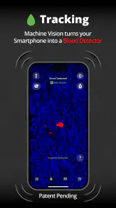
I approached Track N Trail - Hunting & Maps as a practical sports companion rather than a conventional fitness tracker. Its central idea is simple: use a phone as a blood detector while working with land maps. That makes it very different from an app built mainly around steps, running pace, or calorie totals. In my experience, its value depends less on how often you open it and more on whether your outdoor activity genuinely involves following signs across unfamiliar ground.
My overall view is positive but selective. This is a focused tool for people who spend time hunting or exploring trails and want one place for visual land information and tracking-related work. It is not the kind of app I would recommend to someone looking for a general-purpose map, a polished running dashboard, or a replacement for careful field judgment. The best reason to try it is its specific combination of hunting-oriented use and map context, not a long list of everyday sports features.
Where the app earns its place outdoors
The first strength is its clear identity. Many sports apps try to cover everything, then bury their useful tools beneath training plans, social feeds, badges, and statistics. Track N Trail takes a narrower route. The developer, Track'n Trail, has built the experience around outdoor movement and land awareness, with the phone serving as the working screen instead of merely recording a workout after the fact.
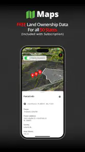
That distinction matters in the field. A normal running app is usually designed to tell me how far I have gone and how quickly I moved. A general map app is better suited to roads, addresses, businesses, and broad navigation. This app is more relevant when the question is about reading the ground while moving through it. The included land maps are therefore not just decorative background; they are the part that gives the blood-detector concept a practical setting.
I also appreciate that the app is free to start. That lowers the barrier for a new user who wants to understand the workflow before committing money. The store listing places in-app purchases between $29.99 and $49.99 per item, so the sensible approach is to install it, learn the basic experience, and decide whether the paid options match the way you actually spend time outdoors. I would not pay immediately simply because the idea sounds specialized.
The app has reached over 50 thousand installs and holds a 4.4 average from around 563 ratings, with roughly 93 written reviews. Those figures suggest that it has found a real audience, although they do not tell me whether it will suit every hunting style or region. I read that level of response as encouraging rather than definitive: enough people have tried it to give the project credibility, but it remains a focused product rather than an unavoidable standard.
Using the map as part of the decision-making process
The most useful way to approach the app is to prepare before leaving home. I would first open the map and identify the area I expect to cover, then think through how the displayed land information will support the outing. The important habit is not to wait until I am already deep in the woods to discover how the screen behaves. A short practice session near home can reveal whether the map presentation feels readable and whether the controls make sense with one hand.
More From Our News Desk

Clash of Clans Is Won Between the Battles

Android Auto Makes the Case for Quieter Car Software

MobiOffice: Transforming Mobile Productivity with Seamless Integration

EA SPORTS FC™ Mobile Soccer: Redefining Mobile Sports Gaming

How Microsoft OneDrive Became a Mobile Productivity Giant

How Google Translate Breaks Language Barriers Effortlessly
That preparation also helps separate two jobs that are easy to confuse. A map can provide context, but it does not replace knowing the terrain, checking conditions, or making responsible decisions. I would treat the app as one layer of information alongside local knowledge and ordinary safety planning. When visibility changes or the phone becomes difficult to handle, the person using the app still has to interpret the situation rather than blindly follow a screen.
A useful field routine is to pause at natural decision points instead of constantly staring at the display. I would check the map before changing direction, after crossing a recognizable feature, and whenever the landscape no longer matches my expectations. This is more comfortable than walking with the phone raised continuously, and it keeps the app in its proper role: a reference tool that supports observation rather than replacing it.
There is another practical trade-off here. A phone is convenient because it combines the map and the detector concept in one device, but that convenience makes battery management more important. I would begin with a charged phone, reduce unnecessary background activity, and carry a backup power option for longer outings. Those are not glamorous recommendations, but they matter more in the field than a clever interface detail. A map tool that cannot be used when needed is not useful, regardless of its design.
Three details that change how I would use it
First, I would use the map before the trip as a planning surface, not only as a live navigation screen. Looking at the area in advance lets me form a mental picture of the route and likely reference points. That reduces the temptation to make every decision from a tiny phone display. It also gives me a way to notice when the actual terrain does not fit my assumptions, which is valuable information in itself.
Second, I would avoid treating a detected blood trail as a complete answer. The detector concept may help organize what I am looking for, but field signs still need careful interpretation. Lighting, ground cover, weather, distance, and the condition of the trail can all affect what I see. The app is strongest when it helps me stay systematic: check the surrounding area, compare the visual evidence with the map, and move deliberately rather than assuming that one screen result settles the matter.
Third, I would establish a stopping rule before beginning. If the map becomes unclear, the trail becomes unsafe, or the available evidence no longer justifies continuing, I would stop and reassess. This is an important trade-off with specialized tracking tools: they can make a search feel more structured, but structure can also create false confidence. The app should improve discipline, not encourage persistence for its own sake.
Where the experience feels limited
The biggest weakness is the narrowness of the product. If I mainly want route recording, running statistics, cycling metrics, or a broad outdoor navigation service, I would choose a more established general sports or mapping app. Track N Trail is interesting precisely because it is specialized, but specialization means it may feel incomplete when my needs move outside hunting and land-based tracking.
I would also be cautious about expecting the blood-detector wording to mean a magical visual answer. A phone cannot remove the need for human observation, and no responsible user should interpret an app-based indication as proof without checking the scene. The concept is appealing because it promises help during a difficult search, yet the practical value depends on how clearly the result can be understood in the conditions where it is used. That is why I see the feature as an aid to a method, not a substitute for one.
The map experience may also require patience from people accustomed to polished mainstream navigation apps. A hunting-oriented map has a different purpose from turn-by-turn driving directions. I would expect to spend time learning what the land information means and how it fits into my own planning habits. Someone who wants immediate, familiar navigation with minimal setup may find that extra learning curve frustrating.
There is a financial consideration as well. The initial download is free, but the available in-app purchases range from $29.99 to $49.99 per item. That is a meaningful step up from casually installing a free map app, so I would judge the purchase by frequency of use. For a person who hunts regularly and will rely on the specialized workflow, the cost may be easier to justify. For an occasional outdoor user, a standard map and a careful manual approach may offer better value.
Because the app is relatively new, I would approach version 1.4.1 with the mindset of using a focused tool that may continue to develop rather than a mature platform with every edge case solved. The release date was Jun 4, 2025, and that recent arrival helps explain why I would test it personally in familiar surroundings before making it part of an important trip. I would rather discover a confusing control or an inconvenient workflow close to home than during a time-sensitive outing.
Who should install it, and who should pass
I think the best audience is a hunter who already understands basic field tracking and wants a phone-based companion for land context. That person is likely to appreciate the app’s narrow purpose, especially when moving through areas where a conventional fitness display would provide little help. It may also suit an outdoor enthusiast who enjoys studying land maps and is comfortable combining digital information with direct observation.
A realistic example would be a weekend search after finding signs in a wooded area. Before leaving, I would review the map and decide which sections deserve attention. In the field, I would use the phone at selected pauses, compare the displayed land information with the physical surroundings, and use the detector-oriented workflow to keep the search organized. If the signs became uncertain, I would mark the point mentally or through my own notes and reassess rather than wandering indefinitely. That approach makes the app useful without handing over all judgment to it.
I would not recommend it as the first choice for a runner, cyclist, or casual walker who primarily wants pace, distance, route history, or workout summaries. A dedicated fitness app will normally be a more natural fit for those goals. I would also steer away from it if I wanted a simple road-navigation experience, because the app’s hunting focus is more relevant than address-based directions.
Newcomers should know that the free entry point does not automatically make the complete experience inexpensive. I would explore the basic screens, check how the maps fit my local use, and only then consider a purchase. I would also test the app with gloves, in changing light, and with the phone held in the way I expect to use it outdoors. Those small checks can reveal more about suitability than reading a feature list.
The age rating is Everyone, which makes the app broadly accessible from a content standpoint. That does not mean every child or inexperienced user should rely on it alone in the outdoors. The important question is whether the person using it understands the environment, the limits of phone-based information, and the need for sensible supervision and safety practices.
My verdict after weighing the trade-offs
Track N Trail succeeds because it does not pretend to be another generic sports dashboard. Its appeal comes from bringing a blood-detector concept and land maps into one hunting-focused experience. I find that combination more meaningful for a prepared field user than a collection of unrelated activity statistics would be. The app gives a specific kind of outing a more organized digital reference point.
At the same time, I would not describe it as essential for everyone who spends time outside. Its usefulness depends on local map relevance, personal hunting habits, comfort with interpreting field signs, and willingness to learn a specialized workflow. The paid items also make it worth testing first rather than buying on impulse. If I only needed ordinary navigation or exercise tracking, I would choose a different category of app.
For the right person, though, the focused design is the reason to try it. I would recommend the free version as a practical first step for hunters who want to see whether a phone can fit naturally into their tracking routine. Start in familiar terrain, plan the outing before using the live map, keep a backup for the phone, and treat every result as supporting evidence rather than certainty. With those expectations, Track N Trail - Hunting & Maps feels like a useful specialist tool instead of an overpromising replacement for experience.
Track N Trail - Hunting & Maps Frequently Asked Questions
Is Track N Trail - Hunting & Maps free to download, and are there optional purchases?
Track N Trail - Hunting & Maps is free to download, so you can try the app without paying upfront. It also offers in-app purchases priced from $29.99 to $49.99 per item, which may relate to optional features or content. Check the purchase details in the app before buying, and consider whether the tools included with the free version suit your needs.
What devices and age groups is Track N Trail - Hunting & Maps intended for?
The app is listed for users of all ages and requires Android 7.0 or later. Before downloading, check your device’s operating system version and available storage, as compatibility can affect installation and performance. Although the age rating is Everyone, the app is designed around hunting and outdoor navigation, so parents may want to review its features with younger users.
What is Track N Trail - Hunting & Maps used for?
Track N Trail - Hunting & Maps is designed to help hunters plan trips, explore hunting areas, and navigate outdoors with map-based tools. It can be useful for marking locations, following routes, reviewing terrain, and keeping important points organized. Before relying on it in the field, users should become familiar with its interface and confirm that the available maps and hunting information cover their intended area.
Does Track N Trail - Hunting & Maps work without an internet connection?
Offline availability depends on the app’s map features, downloaded content, and the specific subscription or plan being used. In areas with weak cellular coverage, it is important to prepare before leaving by downloading any supported maps or route information. Users should also remember that GPS positioning may still work without mobile data, but map details, weather updates, sharing, and other online services may require connectivity.
Can I use the app to identify legal hunting areas and regulations?
The app may provide mapping tools and hunting-related information that help users research public land, boundaries, or potential hunting locations. However, it should not be treated as the only authority for current laws, seasons, licenses, access restrictions, or local regulations. Rules can change frequently, so hunters should verify all details with official wildlife agencies and land managers before entering an area or pursuing game.
Pros
- Offline maps help maintain navigation in areas with weak or no signal.
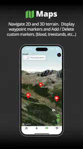
- Hunting-focused map layers make it easier to study terrain and access zones.
- GPS tracking lets you record routes
- waypoints
- and hunting locations.
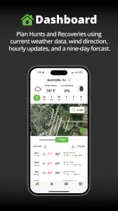
- Weather and terrain information can support safer trip planning.
- Useful for organizing scouting trips and reviewing past outdoor activity.
Cons
- Some advanced maps and features may require a paid subscription.
- Map accuracy depends on regional coverage and available public data.
- GPS use can drain the battery quickly during long outings.
- The interface may feel complex for users new to mapping apps.
- Location sharing and tracking may raise privacy concerns if not configured carefully.
- Category
- Sports
- Version
- 1.4.1