Avalanche Inclinometer
- 8.00
- 4.6
- Installs
- 1.00K
- Price
- $3.99

Screenshots

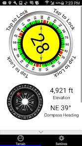
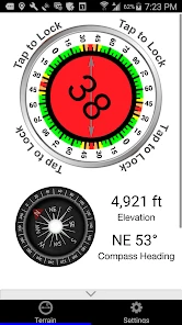
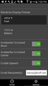
Analysis by Reviewed
I’d treat a slope-reading app as a quick field aid, not a reason to take a line I would otherwise avoid. Avalanche Inclinometer is built around a focused job: helping you check terrain measurements on your phone. That makes it most useful when you already know how to assess winter conditions and want another practical reference, rather than a substitute for training, careful route choices, or a full avalanche-safety plan.
Quick readings, with realistic expectations
The appeal is speed: instead of estimating a slope by eye, I can use my phone to check its angle and see related location details such as elevation, aspect, and latitude and longitude. Those readings can help me pause and think through a terrain choice. They are not, by themselves, a verdict on whether a slope is safe. Snowpack, recent weather, terrain above and below, and the day’s avalanche forecast all matter too.
For a resort skier who stays on marked runs, the app may be more detail than they need. For a backcountry traveler who regularly evaluates terrain, it has a clearer role: a compact measurement tool to consult as part of a broader decision process. I would still check the conditions from trusted avalanche information sources and discuss the plan with my group before heading out.
A useful routine in the field
One sensible way to use an inclinometer is to check a slope from a safe, stable place before committing to travel, then compare the reading with your map, route plan, and current conditions. I would avoid stopping in an exposed spot just to operate a phone. If visibility is poor or the terrain is complicated, a measurement cannot remove the need to choose conservative options and communicate clearly with partners.
A realistic day might start with a group reviewing the forecast and selecting a route, then using a reading at a safe observation point to inform a discussion about a particular pitch. The important step is the discussion, not chasing a particular number. A phone can be awkward with gloves, and handling it in cold weather may take longer than expected, so I’d decide in advance who is checking it and where that can be done without adding exposure.
Compared with a dedicated inclinometer, a phone app is convenient because the device is already in your pocket, but it depends on the phone being usable and held appropriately for a meaningful reading. Compared with a map or visual estimate, it can offer a more direct measurement, while a map remains better for seeing the bigger route picture. These tools answer different questions, and I would not rely on one alone.
Getting Started with Avalanche Inclinometer
So, what's the deal with this app? First off, the setup is a breeze. You download the Avalanche Inclinometer from your app store, and within minutes, you’re ready to hit the slopes. The interface is clean and intuitive, which is something I always appreciate. You don't want to be fumbling with your phone when you're all geared up and ready to shred.
More From Our News Desk
Weather by Xiaomi Review: Clear at a Glance, Less Clear Up Close

X Under Pressure: Can It Recover When Posting Goes Wrong?

Clash of Clans Is Won Between the Battles

Android Auto Makes the Case for Quieter Car Software

MobiOffice: Transforming Mobile Productivity with Seamless Integration

EA SPORTS FC™ Mobile Soccer: Redefining Mobile Sports Gaming
Features that Stand Out
The app uses your phone's sensors to give you real-time data on the slope's angle. Pretty neat, huh? This is particularly useful if you're venturing into backcountry areas where avalanches are a risk. The app also provides a history of your runs, so you can see which angles you've tackled over time. It's almost like having a little diary of your mountain adventures.
Another cool feature is the app’s ability to work offline. Let's face it; cell service is often as unpredictable as the weather up in the mountains. With this app, you don't have to worry about losing signal because it continues to track and record your data offline. This is a game-changer for those deep powder days when you're far off the grid.
Why It's Worth Downloading
One of the main reasons this app stands out is its focus on safety. Sure, knowing the slope's angle is fun for bragging rights, but it’s also a key factor in avalanche safety. The real-time slope angle detection can help you make informed decisions, potentially saving lives. Plus, it’s handy for planning your route and avoiding those sketchy areas where avalanches are more likely to occur.
Let’s not forget the social aspect! You can share your runs with friends and see who’s tackling the steepest inclines. It adds a layer of friendly competition, encouraging you to push your limits while keeping safety in mind. After all, what's a snow day without a bit of fun?
How I’d rely on it—and where I wouldn’t
For a heavy-use day, the useful question is not how many readings I can collect, but whether I can check one without interrupting safe movement or group communication. I’d keep the phone accessible, make a reading at a planned stopping point, and put it away before traveling again. That small routine is more valuable than repeatedly checking a screen while moving through complex terrain.
Offline operation is a practical advantage when cell coverage disappears, but offline should not be confused with a complete navigation or emergency setup. I’d plan the route and carry the equipment and knowledge appropriate to the outing before leaving coverage. I would also make sure the phone has enough charge for its other essential uses; a measurement tool is not helpful if using the phone casually leaves it unavailable later.
There are limits to what a phone-based reading can tell me. The phone needs to be positioned sensibly, and a reading from one spot describes that spot rather than every part of a slope. A convex roll, a changing aspect, or a route that crosses several pitches calls for repeated judgment, not blind trust in a single number. If I need dedicated measuring equipment or a wider terrain overview, I’d choose that instead.
Reading the terrain without overreading the screen
A useful habit is to decide what question I am asking before I open the app. Am I checking the pitch of a specific section, comparing two possible lines, or noting the aspect and elevation of a location for a later discussion? Keeping the question narrow helps prevent the measurement from becoming a general claim about the whole route. It also makes it easier to explain to a partner what the reading does—and does not—contribute to the decision.
I would treat the displayed location details as context to cross-check, not as a replacement for route planning. Latitude and longitude can help identify where a reading was taken, while aspect and elevation can help frame a conversation about the terrain. A practical workflow is to note the observation point on the map, take the reading from a stable place, and compare it with the terrain around it. If those sources do not line up, I would investigate the mismatch instead of picking whichever answer feels reassuring.
One subtle trade-off with a phone sensor is that a precise-looking result can invite more confidence than the situation warrants. The app can provide a measurement, but body position, the exact patch of ground being assessed, and transitions across a slope all affect how useful that measurement is. I would avoid turning one reading into a fixed label for a large face. For a route with rolls or changing angles, several carefully chosen observations are more informative than a single convenient one, provided taking them does not put anyone in a worse position.
Where it fits among winter tools
The usual alternatives each have a different advantage. A map helps me understand the route as a whole and plan where a decision point might be; a visual estimate is immediate but can be misleading; and a dedicated inclinometer keeps the measuring task separate from a phone that may also be needed for communication or navigation. This app’s appeal is that it brings a slope check onto a device I may already carry, with elevation, aspect, and coordinates alongside the angle. Its trade-off is the same one that comes with any phone-based tool: I need a usable, protected, sufficiently charged handset and a safe moment to handle it.
That distinction matters most when a group is moving through terrain rather than standing at a trailhead. I would not pull out a phone simply because the app makes a measurement available. If the group is exposed, weather is worsening, or a partner needs attention, the right choice is to keep moving to a safer place or stop the measurement altogether. A dedicated instrument can be a better fit for someone who wants a simple, separate device, while a map remains indispensable for choosing where to go in the first place.
Price, compatibility, and the right audience
Developed by Iterum, LLC, this sports app costs $3.99. It has a 4.6 average from 19 ratings, with 1K+ installs, and its current version is 1.2.0. It is rated for Everyone and requires iOS 8.0 or later. I’d see the purchase as worthwhile mainly for someone who expects to use slope measurements regularly; occasional resort visitors may get little value from a tool they rarely open.
The practical fit also depends on your device and habits. Before relying on a phone in winter, I’d check that I can handle it with my gloves, see the display in the conditions I expect, and keep it protected from cold and moisture. If using a phone outdoors is a hassle, or if I want a dedicated instrument that does not compete with communication and navigation for battery, a separate inclinometer may suit me better.
Who is likely to get value from it?
I’d recommend it most to a backcountry skier or winter traveler who already makes deliberate terrain decisions and wants a compact way to check a pitch during a planned stop. It is also more appealing if the phone is already part of your outing kit and you are comfortable using its sensors carefully. Someone who measures terrain often may appreciate having the angle and location context together, while a person who rarely leaves marked routes may find the tool sits unused after the novelty wears off.
I would skip it as a stand-alone safety purchase if you are new to avalanche terrain and hoping an app will tell you which slopes are safe. A measurement cannot replace training, current forecasts, rescue equipment, partner communication, or conservative choices. I would also favor a dedicated instrument if cold-weather handling, battery competition, or keeping a phone protected makes a quick check impractical. The right choice depends less on the app’s convenience than on whether it fits a safe routine you can actually follow.
A realistic check before committing
Picture a group approaching a planned slope and pausing at a sheltered observation point. One person can check a particular pitch while another follows the route on the map; then they can compare the result with the forecast, the surrounding terrain, and what they have observed during the day. If the reading raises a concern, the group can discuss a different line or turn back. If it appears unremarkable, that still does not settle the decision—the app has contributed one observation, not issued permission to proceed.
That is where the app’s focused role makes sense to me. It can turn a vague impression into a measurement worth discussing, but it should not encourage a group to approach an exposed slope just to get a better number. I would choose the observation point first, make sure the check does not distract from the people around me, and put the phone away before moving. If there is no safe place to take a reading, I would leave the reading untaken.
The Final Verdict
In short, if you're hitting the slopes this winter, the Avalanche Inclinometer is a must-have. It's user-friendly, reliable, and focuses on the important stuff—keeping you safe while you enjoy the ride. Whether you're a pro or just starting out, this app adds value to your mountain adventures. So, go ahead, download it, and let it guide you through the peaks and valleys of your next snow-filled escapade!
My more careful recommendation is for experienced users who understand that a slope angle is one piece of an avalanche assessment, not a green light. The app’s focused readings and offline use can make it handy in the backcountry, but I would not call it essential for every skier, nor would I rely on it as my only safety resource. Used as a prompt to stop, measure thoughtfully, and talk through a decision, it has a sensible place in a winter kit.
Avalanche Inclinometer Frequently Asked Questions
What does Avalanche Inclinometer help me check in the mountains?
Avalanche Inclinometer is intended for people who want to understand the terrain they are moving through. Its summary highlights slope, elevation, aspect, and latitude and longitude, making it a tool for checking several details of a location rather than just looking at the angle of a hillside. Those readings can support planning and awareness in avalanche terrain, but they should be treated as one part of a careful approach to mountain safety.
Who develops Avalanche Inclinometer, and what does it cost?
The app is developed by Iterum, LLC and is priced at $3.99. That makes it a paid download rather than a free app, so it is worth considering whether its focus on terrain readings fits your outdoor plans before purchasing. Avalanche Inclinometer is in the sports category, and its audience is likely to include people who spend time in snowy or mountainous areas and want useful location and slope information close at hand.
What is Avalanche Inclinometer and how does it work?
Avalanche Inclinometer is a specialized app designed for outdoor enthusiasts, particularly those involved in activities like skiing and snowboarding. The app helps users measure the slope angles in mountainous terrains, which is crucial for assessing avalanche risks. By utilizing the device's built-in sensors, the app provides accurate slope readings, helping users make informed decisions about their safety in avalanche-prone areas.
Is Avalanche Inclinometer available for both Android and iOS devices?
Yes, Avalanche Inclinometer is available for download on both Android and iOS platforms. Users can find the app in the Google Play Store for Android devices and the Apple App Store for iOS devices. This cross-platform availability ensures that a wide range of users can benefit from the app's features, regardless of their preferred mobile operating system.
Does Avalanche Inclinometer require an internet connection to function?
No, Avalanche Inclinometer does not require an internet connection to perform its primary function of measuring slope angles. The app utilizes the device's built-in sensors to calculate angles, allowing it to work offline. This feature is particularly beneficial for users who venture into remote areas where internet connectivity may be limited or unavailable.
Pros
- Accurate slope measurements.
- User-friendly interface.
- Real-time updates.
- Compatible with most devices.
- Offline functionality.
Cons
- Limited advanced features.
- Occasional ads.
- No cloud backup.
- Basic design aesthetics.
- Requires precise calibration.
- Category
- Sports
- Version
- 1.2.0